So excited by the chance to go on Andy’s Conservation Area Loop (what I’m calling it anyway) was I, that I cut short New Year’s riding to return home and prepare for it. Aiming to string together a number of parks and their tops using farm tracks to that have only relatively recently become accessible sounded a grand idea to me – this plan had been fermenting in Andy’s mind for a while. What’s more, the forecast steadily improved in the week before. We had five days to ride the 300+ kilometre route; knowing little of the country, except that it would be very hilly, four days seemed likely for a good touring, definitely not race, pace.
A big breakfast in a Kurow cabin and a civil seven-thirty start and we were away up the Alps2Ocean. I’d not ridden the longest cycle trail in the country in its entirety for many years, so was pleased to find that a lot of more of it has been taken off the Waitaki Valley highway. It was still early and warming well, we wondered if we’d gotten things completely wrong watching the pleasure boats on the hyrdo dams.
 Across Lake Benmore from the dam remembering previous trips on that lumpy pylon access road.
 Across the dam and there’s now a trail up there, instead of going through Otematata down at valley floor level.
 Looking over Otematata Station to the Hawkduns brought back memories of stinking hot days climbing up there less than a year ago on the first Tour Te Waipounamu. Comparisons to and memories of our respective TTW races would be a regular topic, such was its significance in our bikepacking lives.
 I was thrilled that this new section of A2O took us high above the lake to give views of parts I’d not seen before.
There was some steady climbing, but equally fun downhills, and the section to Sailors Cutting provided a good warm-up. It’s a popular trail and there were plenty of riders to greet as they rode the, preferred, opposite direction. I think it’s just as good as the more-hyped Lake Dunstan Trail – the views are less confined, and there’s no highway noise for starters.
 Still surprised at just how green this normally barren area is looking this summer.
The standard big meal at Wrinkly Rams consumed, we were soon out into the afternoon for a hour of gradual highway climbing towards Lindis Pass. Holiday traffic wasn’t too bad, none of the big rigs I’m used too. We continued up the Ahuriri valley as the highway turned towards the pass.
 Almost another hour up the wide valley, getting closer to the access easement.
 Andy’s photo.
 Stunner, hot afternoon.
 We were advised to cross the Avon Burn as soon as possible and stick to the farm track, much easier going than the nearby poled route.
 The track soon left the stream with some steep pinch climbs.
 As we got into the hills, we constantly pondered just which track we would soon be ascending. Andy’s photo.
 We found this sweet, old private hut just before the long push began.
Available to stay in for a small fee, it was a beaut. Around four o’clock, most of us were tempted to call it a day there. But we’d not even managed a hundred kilometres, and little climbing – it was well too early to waste such kind, calm conditions. There began two hours of mostly walking through six hundred metres of ascent. All on reasonable double-track, the pushing was easy enough – that is, wheels rolled and there was no carrying.
 Looking up to the big switchback, that was almost halfway up the total climb.
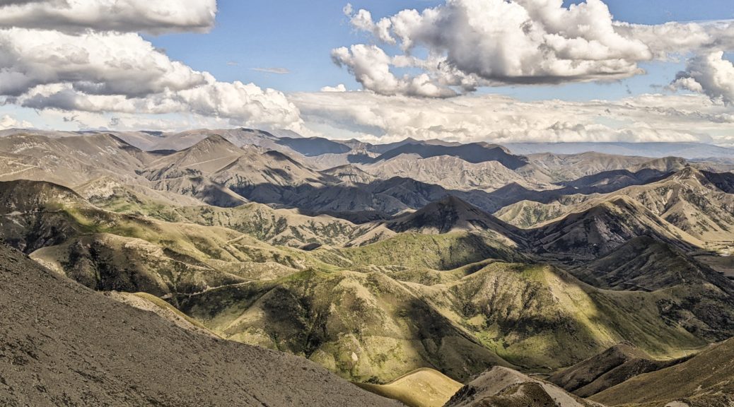
The views changed constantly and they were staggering. Spotting all the similar tracks dozed across and up other hills was a favourite – I want to explore them all!
 Back down Avon Burn, the hut near those yards.
I’d been a bit nervous about recent medical things, so forwent a comfortable tent for a bivy bag and a stove for dry, cold meals (the forecast was good) to save a bit of weight – this helped to keep my bike moving a little faster. Rachel and I both left backpacks behind, but both found adequate solutions to strapping our front packs to our back to lighten bikes further for prolonged pushes.
 Looking south before switching back and crossing that face two pictures above.
 Running out of words for a while.
 I can see at least eight tracks there I want to explore!
 Into Otago now and the start of the Lindis River, we’d be down there soon enough.
 Waiting a bit, scoping out more tracks.
 The trail changed for the last few kilometres to the summit, with a little dip around the corner to climb out of.
It was so unbelievably still at the top of the Melina Ridge track, I was more than happy to linger waiting for Andy and Rachel – soaking in the views all around and scheming further adventures now that my eyes helped me to grasp the possibilities that a friend had mentioned on my arrival to Otago.

 Tough place for fenceposts.

Eventually we were able to draw ourselves away from the views and set off down.
 Through the gate into our first conservation area, I was not stopping on the downhill that presented itself.
Screaming down through a five hundred metre drop in ten minutes of big switchbacks and plenty of bouncing around on my loaded, rigid bike was oh so much fun. So much fun that I have no photos. I’d apologise, but it was completely worth it! Much possibility to come back with a trail bike (not far off now, new one is in the country).
More waiting (eight minutes, which is not bad considering how much more media the others got) gave the chance to top up bottles at the creek and sit on a big rock in the sun looking down the valley.
 Another climb from that stream did at least give a good view of the bottom part of the descent. One can see the Mt Melina track, that left the ridge track at its highpoint.
Now down in the Lindis valley floor and past the turn off to Mt Prospect (another riding possibility), nearing a twelve hour day, with the sublime Melina Ridge in there, seemed a reasonable time to look for a nice campsite before getting too close to the highway. We found a sheltered one on some river flats near a tributary that we would turn up the next day and set ourselves up for the night. What a fantastic day of brilliant weather, amazing new views, great company and excellent riding – the pushing wasn’t even that bad either.

 Out of Oturehua on the Otago Central Rail Trail.
 Starting the climb, over the Manuherikia Valley to the Raggedy Range.
 For once I had the time and inclination to make the small detour and check out this wee old hut. A pleasant spot for second-lunch.
 Thomsons Saddle.
 Headwaters of Thomsons Creek, the stone hut just around the corner.
 One day, hopefully soon, I’ll go up there. Now I’m in the area, there are many little side trips to be found and explored.
 The restored Come In Time Battery.
 Over the Lindis River.
 Heading to Cornish Point.


 There’s the occasional climb, but nothing significant on a loaded bike.


 As well as the scenery, which was probably not helped by the gloomy day, I enjoyed having the time to read all the signs detailing history and engineering in the area.

 Saying goodbyes.
 Actually stopping to read the interesting displays at Lauder.