With the ever-kindness of friends, it was an easy decision to extend a hectic one-day conference trip to Rotorua to include staying at Lake Tarawera, catching up with friends and a little mountain-biking.
An interesting day stuck inside over, I had a bit of time before meeting Roger at a self-billed craft beer pub in Eat Streat. My step count (this corporate challenge thing is good motivation for ensuring a moderate level of daily activity) having suffered from sitting in a conference room all day, this spare time was easily accounted for with a stroll down to, and around a little of, the shore of Lake Rotorua.
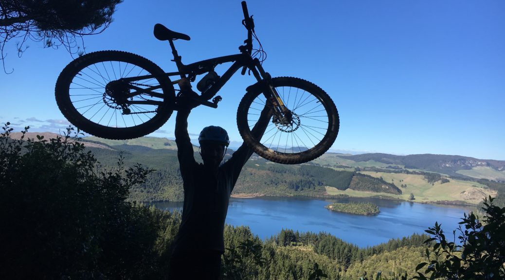
 Bike tree!
Absolutely years since I’d been to the living Maori village of Ohinemutu, it was a pleasant stroll in the fading light amongst the buildings and geothermal steam.


I retraced my steps through the village and continued around the lake for a while, finding more paths that I can’t remember the last time I walked – probably as a child, having lived forty minutes’ drive away.

Walking back past the museum, I found Roger quite at home at Brew – he’d only been living in Rotorua a matter of weeks. With tasty beer to add to the occasion, it was great catching up once again – a lot of talk about bikes, naturally. Planning the following day’s ride was also high on the agenda.
A stunningly clear evening led to a frosty start as we met Luke (another ex-Pukekohe biking buddy) for an early ride in the forest. I’ve ridden with Luke a bit over the last few years here, but Roger & I could marvel at how great it was to be out for a Rotorua sortie. I’ve since checked, it was over eight years between such rides – well too long! Even with all the riding I’ve done in the forest over twenty-plus years, I’m still being shown new trails. It seems the locals can build fantastic trails faster than I can ride them.
Luke took us off-piste to ride a recently developed/developing trail in a part of the forest I rarely go – and so close to the old parking lot. The first half was mostly rideable for me down the side of a loamy forested slope; but then it got steeper with a narrow ribbon of a rut cut in the dirt – I lost my footing once trying to walk down it. Such fun but.
 Follow that ribbon.
 Surely I’m somewhere further up the hill treating the roots a bit more circumspectly.
 Back out in the open, it was fresh on the skin and crunchy under tyre.
Tumeke was another trail new to me, graded at about my limit it was great fun and rideable for me until the very bottom. His home calling, Luke left us to head further out. With another trail I barely remembered completed, Roger & I opted for the shuttle to enable us to head to the extremity of the forest in a timely manner.
From the drop-off point we charged up (well, it was charging for me) to Tuhoto Ariki – a wonderful piece of rooty singletrack through native forest. Beautiful riding, we had an absolute blast constantly marveling at the trail and its sublime mid-winter condition. My riding diary tells me I last rode this in 2007, when it was quite new – I remember it being muddy and rather hard work. Perhaps I’m a little fitter now, but it surpassed all my expectations – twenty minutes of challenging singletrack bliss.
Further out is Kung Fu Walrus – we tootled out there, I remembered it fondly from May. This time I was hoping that the last hundred metres wasn’t closed for logging – poor trail closure signage (i.e. none) that time necessitating a big push back up the hill.
 There may be a lookout over Green Lake just before the trail. I also may have been having a sufficiently good time.
Another fun trail, there is plenty to keep me on my toes – and a few things I can’t quite ride every time. Which is great to keep me coming back to master them. Heading back to the van, there was yet another new trail for me: the much more mellow, but still enjoyable, Taura. Nearing the end of the ride, for old time’s sake, I nipped off for a quick blast around the Dipper (my earliest memories of MTBing are on this trail). Somehow in the few minutes I left him, Roger had managed to talk himself into a job of doing a pre-race sweep (checking signs, tape etc.) of a fifty kilometre course early the next morning. I say “job”, but something so pleasurable can’t really be called so.
I had planned to leave Rotorua that afternoon to return home for the final in the local cyclocross series which I’d been riding in (and much to my surprise, winning the B-grade on my MTB). But all this time with old friends and actually riding trails rather than muddy, grassy laps of a vineyard had me questioning my decision. I popped back to the lake for lunch before heading out again to catch up further with Luke and his family. I eventually ditched my cyclocross plan for riding proper trails, thus staying another night.
It didn’t seem so cold out at the lake early Sunday morning, but as I drove into Rotorua the cloud descended and the mercury dropped. Roger and I met for another frosty ride, hitting the 50 km course about quarter to eight. Snaking around some of the inner trails for quite a while, it was good fun in the trees before heading out into the open. Exposed to the cold, the surface was hard and we found ourselves sliding around a few corners.
 1ºC is still shorts weather.

Rolling along the Creek trail we found a little bit of barrier tape to reinstate, but that was about it – mostly we just rode bikes and had fun in the excellent dry conditions. About fifteen kilometres in Roger realised he didn’t have the energy after the previous day’s ride and a few weeks of illness. Not to worry, I was happy to ride on, up the only big hills on the course and discover some more new-to-me trails. I thoroughly enjoyed heading out the back of the forest again. Realising I might be caught by some fast racers (they started ninety-odd minutes after us), I barely stopped.
Returning to the western side of the forest, the long-course confusingly rejoined parts I’d already ridden – and plenty of riders just heading out. From here there wasn’t much point in carrying on riding the course as the short-course racers were already there. I zipped down the old exit trail to finish my ride – it was good fun putting in a good three hours of riding with little stopping, and getting a few PBs.
 Roger’s bike was waiting with Marlena.

Somehow I ended up with another bike to take home with me – Roger lending me a steel singlespeed to have little bit of a go on before the Worlds in November. Saying goodbye amidst promises to not leave it so long between Rotorua rides, I popped back out to the lake to clean up and pack. What a great weekend with old friends and bikes. Special thanks to Terry and Bronwyn for having me to stay, yet again. I was safely back in Napier before it even got dark – that makes the drive so much easier.
 Looking south, the hill has a few cabbage trees dotted on the exposed slopes.
 Pausing for a breather across one of the valleys seemingly cut in the hill.
 Great clefts cut in the landscape.
 Lovely folds to appreciate in the landscape. Looking out towards Napier in the weakening light.
 Making a sheep-line out of the valley as our approach was noted.
 Down that slope, deep into that gully.
 Yip, down there.
 Quite bumpy in the middle.
 Te Mata Peak looking a little shorter, and quite different from this perspective, at the left of shot.
 Looking south up the Tukituki River.
 Leaving the Hill behind, over Westshore Bridge I followed my commute route for ten or so kilometres.
 What’s this? Offshore power boat racing. That’s different. Not to mention loud, fast and repetitive.
 I was heading for the coast in the far distance, just right of centre in this shot.
 The crossing of the Esk is at the start of Waipunga Rd, before the hills start. It’s looking a bit lower than a couple of weeks previous, when we had 200 mm of rain in less than forty-eight hours at work (process water at work is taken from the Esk).
 In the mid-afternoon sun (warming enough to only need arm warmers in addition to shirt), the climbing began – as did the views of rolling green hills and distant ranges.
 The largest part of the climb ascends this ridge from right to left, steadily gaining about three hundred metres. It’s very nice.
 I really enjoyed the gradual climb – stopping often to snap photos to share.

 Eventually, the road starts to roll up and down a bit more – gradually climbing overall.
 I paused at the end of Waipunga Rd to look north – this was as far north as my route would go, and also the highest altitude. I had five hundred metres to lose in the twenty kilometres to the coast.
 I turned right onto Kaiwaka Rd – more lush gravel! I headed for the highway to cross it.
 The sun sunk further, setting nicely on this rather out of place patch of toetoe.
 More hills – thankfully I didn’t have to ride them all.
  I kept a watchful eye on my shadow as I lost altitude quickly.
 It seems one can’t really escape work – the pulpmill steaming away on the right; Napier easily visible stretching left across the water, the hills south of Havelock North in the distance.
  I said my goodbyes to cell coverage with one big downhill, a few hairpins and cool rushing air as I blasted down to Waipataki and the sea.
 First I had to work out how to cross the stream.
 Big stepping stones helped, I didn’t fall in; just.


 It quickly became apparent that it was to be another stunning autumn day.
 Pedaling up the driveway, the day’s only sizable hill rose in front of me.
 The highway gets rather close to the coast and the puffing pulpmill comes back into view.
 And just like that I was nearly home, back on my commute route.
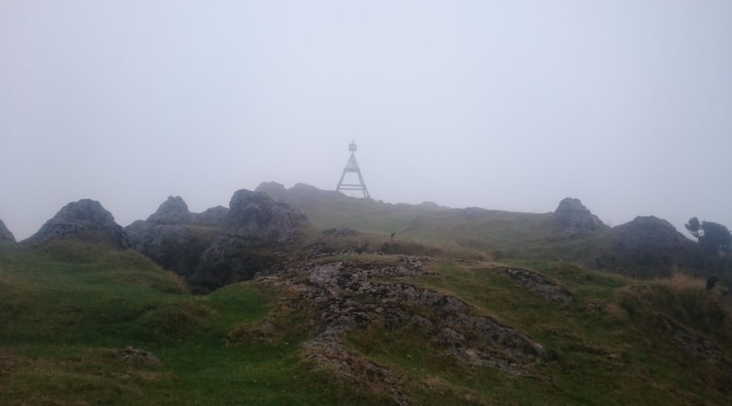
 Definitely getting closer to the clouds as we reached the summit of the road. This looks north, we turned south onto a paper road and kept climbing.
 This view would normally look out over the Pacific in the distance. Not today. We turned onto the next paper road near that small solar panel on a pole.
 We stood around and pondered for a while as to which way to go. I apparently took to riding wearing only one glove a fair bit.
 We were getting into the clouds further and further. Route finding became challenging, but it was decided our path continued to climb (not the track you can just see in the picture, we went up further into the clouds).
 Just as well it was worth it all for the views.
 We saw hints of the ridge and the bluffs.
 Here we pass our first fallen tree….
 Still we climbed through the murk; this road is definitely only on paper.
 Shaun finds the route.
 Ignoring the peril, I’m still managing to lift my bike here.
 That’s a lot closer than it was!
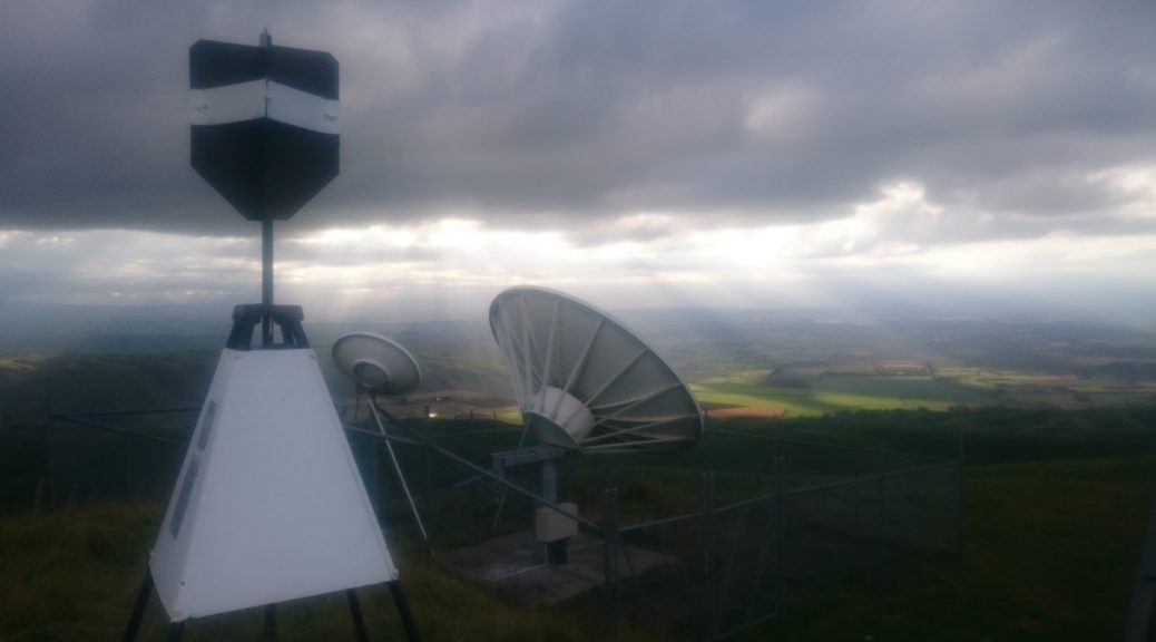
 The transmitter tower, looking rather spooky in all that cloud.
 Our only mechanical of the trip – not entirely helpful, but it was quickly repaired!
 Out of the clouds. Just.
 Which meant we had to push up that hill in the centre of the picture, just to the right of the pines. That was after avoiding a large bull that had quite a stare on it.
 I pottered over a stream on the farm before making it not very far up the hill – there was a lot of pushing to the top of that ridge.
 Only a couple of twenty metre cliffs between where we stood and the field on the other side – where we wanted to go.
 The Mangaone River was quite nice; a packraft would have been nicer.