Category Archives: family

Wanaka weekend

With the possibility of quite a few rides, I was easily persuaded to join Adele, her boyfriend James and another couple of their friends for a weekend camping near Wanaka – this being in the beautiful Southern Lakes area of the South Island. Unfortunately, the weather didn’t particularly play nice for the majority of the weekend – but it wasn’t so nasty that I didn’t manage five rides, even if they were on the short end of the scale.

First up, we stopped off en route in Alexandra to meet Garry so that Adele could have a bit of Canadian canoe practice for the upcoming adventure race. As I’ve been shuttled so many times in a car for mountain-bike rides, I was happy to play shuttle driver. In between dropping them off up the Clutha River near Clyde and picking them up downstream in Alex., I managed to get in a quick hour long ride up & back down the Anniversary track beside the same river. It was strange to have a time limit on a ride and quite fun to actually have to push the pace consistently to make sure I got there and back to meet them by the three-thirty deadline (which I did).

After much talking of gear for the adventure race, paddling techniques (there is also kayaking in the race), more of the delicious Christmas cake (from last weekend’s ride) and cups of tea we left Garry’s house for Wanaka. As we arrived much earlier than the others, we got in an evening lap of Dean’s Bank (a very nice little ten kilometre MTB track on the edge of the Clutha River just as it drains Lake Wanaka) before heading into town for dinner & last-minute camping supplies. Somehow my tent got up while it was still dry, about the time the others (Jacqui & Dan, with James) arrived the rain set in for the night. Late to bed, a couple of hours of riding obviously wasn’t enough to wear me out – I slept horribly.

I think we had the best of the weather on Saturday as we sat eating our bacon & eggs before all of us headed across the road to Dean’s Bank again. Very much the gooseberry with two couples, I had no qualms in leaving everyone to go their own pace while I had a bit of fun seeing how quickly I could get around the very enjoyable loop. Not content with just waiting for the others, I got in another two-thirds of a lap as the rain tried to start again. Lunch was by the lake (Wanaka) as we contemplated the grey clouds in the distance where we wanted to ride. In time, we resolved not to let the weather put us off and drove up to West Wanaka to start the ride to Minaret Burn.

Setting off near the lake, after having crossed the Matukituki River, there was one good steep climb to get our hearts going as we climbed above the water to what I’m sure are very nice views on a sunny day. Despite the gloom and rain, it was still beautiful country with rugged hills still displaying many different shades. Jacqui & Dan, somewhat sensibly, decided riding into rain and a stiff breeze wasn’t really for them and turned around. Less sensibly, Adele, James & I continued. Things leveled out a bit after the five-kilometre mark; but as we could see the trail switchbacking up a very steep & large hill and the rain showed no signs of easing I was informed we would be turning back before said hill. We’d been getting our feet even wetter than the rest of our clothes already were crossing streams, so when we got to a swollen river it was easy to turn around and avoid the swift, high water.

I tried to get a photo in the rain – not sure it was worth the effort; Wanaka township is down the far end of the lake, somewhere.

Even after the previous weekend’s epic, but equally fantastic, ride – Adele had not been put off asking Garry to organise another training ride. This time obviously we were looking in the Wanaka area for a big back-country outing. The DoC (Department of Conservation) office wasn’t particularly helpful, but Garry brought along a couple of other suckers-for-punishment. One of them, Phil, turned out to be even madder at choosing routes into the hills than Garry (I remember the words “it was easy in a four-wheel drive”). Starting near Lake Hawea, we pretty much climbed solidly for nine kilometres at an average of ten percent gradient. The surface was reasonable – I only had to walk about a hundred metres just after the gradient really kicked up as we left the valley floor and all the stream crossings.

With quite a bit of cloud around and the valley being quite close, the views weren’t nearly as expansive as last week – but it was a steep-sided dramatic valley we were slowly climbing out of. Phil was a fount of information about the area as he had been involved in the tenure review of this land in the last few years (a lot of high country in NZ is crown-owned, but given over to long-term leaseholders – every so often [not actually that often] this comes up for review with respect to conservation, land-use for farming, public access & so on).

Once we reached the conservation park (which had been handed over to DoC guardianship after the last tenure review) the trail quickly changed from the rough farm track to benched trail designed for mountain-biking and walking and the gradient eased off a bit. The changeable weather continued to do so and we were kept guessing as to what would happen. After more steepness on farm trail, as we approached a saddle the wind and rain was really blowing across. We sheltered from the wind to have lunch number two and tried to keep warm as the rain fell. Halfway through my sandwich, the rain stopped and my jacket started to dry out. When it was put to the group as to what we should do with respect to carrying on or not in the poor weather (the clouds were really blowing up & over the ridge), all was silent until I finally stated I was happy to keep riding – never a good idea for everyone else to stay quiet for so long.

With a bit more climbing to see what was around the next corner and how the different those clouds might look, we set-off. Of course, it wasn’t just one more corner we rounded – there were several as the view constantly changed and the weather abated for us slightly. At about the twelve kilometre mark, we could see the ridge track stretching off in the distance and the weather still looking rather poor – we all agreed it was time to turn around and meet our deadline to be back at the cars by four o’clock.

That’s what the clouds looked like around the corner, in case you were wondering.

The valley we climbed out of – trail on left hand side of photo, thankfully.

The descent surface was not nearly as gnarly as that which we ended last week’s ride on, but with all that climbing we’d done – it was great fun and fast. Except as the weather was a bit brighter, I kept stopping to take photos & wait for the others. For historical reasons, I’m told, we ditched the bikes briefly and walked a short distance to a peak to look over the plains and lakes below and marvel at how great the view must on a clear day.

We didn’t ride down there.

As we got off the ridge proper, the sun came out and it warmed up.

We all made it down in one piece, I had a complete blast on the downhill again (I really must get a job so I can justify getting a bike more suited to such things) and while not nearly as memorable in distance or views as the previous week’s Sunday ride it was an outing thoroughly enjoyable with good riding buddies. And most everything was loaded in or on the vehicles before the heavens opened again.

Buster Diggings – Johnstones Creek Track epic

One of Adele’s teammates for the upcoming adventure race, Garry, thought that a good training MTB ride for Adele would be the Buster Diggings & Johnstones Creek Track combo. Naturally, I thought this was a great idea as Central Otago is beautiful and riding bikes is great. It’s not a well-known trail, not even making it into the NZ MTB trail bible (Classic NZ MTB Rides), so we were a little taken aback as we checked it out the night before. Over two and a half thousand metres of climbing in sixty kilometres?! It looked like it would be a long day – especially as Adele has not spent much time riding recently.

Consequently, it was an early start for the eighty minute drive to Naesby (which I am assured has great MTB trails in the forest – but I’ve not ridden there, yet) to meet Garry. Having arranged a car shuttle we left town & managed to drive a few kilometres up the Mt Buster road before setting off on our bikes – Adele taking her brand new one for its first outing. It was a glorious day and the first few kilometres along the undulating gravel road were pleasant riding. Before long we were entering the Oteake Conservation Park and the first of three tough climbs began. Progress slowed markedly as it took over an hour to go 3.5 km and climb almost 600 m! The surface was pretty good (all of the day was spent on double-track/4WD track), with just one particularly rocky & loose section causing me to push my bike for a hundred or so metres. I had plenty of time to take photos while I waited, so here are a few of typical Central Otago hills & plains – the hills invariably covered in long tussock (a type of grass found in the high country around NZ).

Entering the conservation park, looking ahead to the first big climb of the day.

Part-way up, looking south over Central Otago.

In that pick-up are the only people we saw all day – we were out for over ten hours and only heard birds, streams flowing & the breeze (apart from any sound we made obviously). It’s quite remote up there.

Eventually the hill plateaued and we got some respite. We took a small side trail to look at Buster Diggings – the result of the highest gold mining ever undertaken in NZ at 1200 m above sea level (Otago had quite a gold rush in the nineteenth century).

The results of alluvial mining, and Mt Buster in the background.

A lot of our hard work was undone as we plunged off the plateau down to the head waters of the Otematata River below.

After the quick descent, we followed the small river for about fifteen kilometres. Often we had to cross the river – I lost count of the number of river crossings we made, probably up around twenty. All except three were rideable with the current level of water in the river. Before another climb started, we stopped at Tailings Hut for a bit of lunch. Somehow twenty-six kilometres had taken four hours – I think we deserved some food and a bit of rest.

A typical NZ back-country hut – and Adele’s brand new bike no longer so clean & immaculate.

From the river, it was another steep climb around the end of the ridge – but this was much shorter before plunging to the river for another crossing. Unfortunately, at the high point in this section we could look across the valley and see what was to come.

All the downhills of the day were great, and not just because they were such welcome relief.

Yes, another opportunity to get one’s feet wet – by this point Adele was quite soaked due to a previous unplanned dip further up the river.

That was a small part of what was to come.

This was the most brutal climb of the day – six hundred metres up in only five kilometres along. The first half was noticeably steeper than the second, but the surface was very good and it was all rideable for me. With the sun beating down, it was getting hotter as the we were sheltered from the wind. Regrouping on the next plateau, the riding got easier – but was still generally climbing.

Waiting on the plateau amongst the tussock.

Eventually we came across the second hut of the day – the Ida Railway hut. Originally down on the railway that was converted to the famous Otago Central Rail Trail, the old station was somewhat unbelievably hauled up the route we had just ridden some decades ago for use as a musterers’ hut. I was pretty thrilled when Garry pulled a large slab of Christmas cake from his pack (he was wearing the large, for mountain-biking, pack that seems to be standard equipment for their team in the adventure race). It was good cake and excellent to be sitting out in the sun in the wilderness with great company enjoying it as the stream babbled close by – especially sharing a big bike adventure with my sister.

The climbing reared up a bit more across the plateau as we got to our highest point so far that day – about 1550 m. Across the plateau we could also look north to the Southern Alps and pick out Mt Cook (NZ’s highest mountain) easily.

Looking back across a small part of the plateau we’d ridden across. For perspective – if you look very closely you can just see Adele rounding the corner at the right of the shot.

Depending on whether one was climbing or descending (for me, at least), unfortunately & then fortunately (respectively) the trail condition got a lot poorer from this point on. The Canterbury greywacke stone used to pave the route suddenly became much larger, looser and more sharply edged. As I alluded to above – this was fantastic on the next steep plunge as the riding became much more technical and thrilling.

But after that steep plunge, we were left looking at this:

About a quarter of the last climb of the day…

While not the toughest, biggest or longest climb of the day – due to the poor surface it was definitely the most technically challenging. Starting off at the bottom I was starting to feel a little tired, but from somewhere found some energy and managed to ride all but about a hundred metres when it just got too loose & tricky. Whether going up or down on the chunky loose rocks, I found it much easier to carry a bit more speed than normal to avoid getting bogged down in the greywacke.

Finally we were at the magic point of no-more-climbing, looking out across Central Otago again. All that hard work in the sun was about to be rewarded by a glorious, fast descent dropping 800 m in five kilometres. That was even steeper than what we had climbed – I would not recommend riding this route in the opposite direction considering the surface at the west end. I know the other two didn’t really enjoy this rather technical, steep downhill (Garry had been preparing us all day to be disappointed with it after all the work taken to get there) – but I was grinning all the way down. So many big rocks moving all over the place, plenty of water bars to jump off and a grand view.

You can just see the trail snaking its way down from the right of the Hawkdun Range.
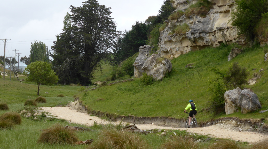
With a few more miles to ride down on a gravel road to where Garry’s car was waiting for us, there was plenty of time to savour the biggest, hardest and most-epic day mountain-biking I’ve had in ages. If even obscure trails like this that I’ve never heard of are so good, that bodes well for the rest that this country has to offer – perhaps I’ll be able to stay, now I just have to find a job sometime.

Alps 2 Ocean – Duntroon to Oamaru section

In the time since I left New Zealand, extensive work has been done around the country to develop a large number of cycle trails – rather obviously The New Zealand Cycle Trail. While most are a lot tamer than mountain-bike trails I usually prefer to ride, the trails are in some spectacular parts of the country. Browsing the website during my last winter in the UK, I got quite excited by the chance of riding some of these trails over the coming summer (& beyond) to try & reacquaint myself with the country. Especially if they’re anything like the Queen Charlotte Walkway – the only one I’ve done before & the best multi-day bike trail I’ve ridden.

Both Adele & I have to do significant training on our mountain-bikes for upcoming events. Adele is doing her first adventure race – Godzone at the end of February; I think she is mad. I for some reason have signed up for the Kiwi Brevet at the start of February – 1150 km of bikepacking in a maximum of eight days; I may also be crazy – but at least I’ll see a lot of the top of the South Island. So to kickstart our training, an easy little ride at the top of the final section of the Alps 2 Ocean cycle trail coincided well with a dentist appoinment in Oamaru.

The Alps 2 Ocean trail runs from the shadow of Mt Cook (NZ’s highest mountain) in the Southern Alps for just over three hundred kilometres to the Pacific Ocean at Oamaru (overall south-east). Having spent some time in the area previously, I can safely assume the whole route must be a beautiful ride. With only a few hours, not a few days, we drove to the start of the final section of the trail in Duntroon and determined to ride out and back as our time allowed. We had about four hours so I thought we would get half of the distance to Oamaru (55 km) before having to turn back to the car.

The section starts off gently enough on quiet highway towards Elephant Rocks. Very soon there is a dedicated cycle path beside the road – always nice to be off the road, even when there is next to no traffic. Passing Elephant Rocks, Adele managed to deal with not having her rock shoes with her – the limestone rock formations are very popular for bouldering. Passing an abandoned film set (the area has also be used for various films – the Chronicles of Narnia series probably the most well known) the trail departed from beside the road across farmland.

Over Elephant Rocks – very pleasant riding weather, not so good for photos.

Having both spent a lot of time in the area (Adele in particular – my family spent most of the last fifteen years living in Oamaru after I finished high school), we weren’t expecting too much from the scenery – just wanting to go for a nice ride. However, soon we were riding up a narrow valley surrounded by limestone cliffs before some tight switchbacks took us above the cliffs and through more farmland and it was lovely; at times the views opened up.

Since leaving the highway we had been climbing gently; cresting the hill the trail surface deteriorated – up until this point it had been very good, but here it seemed most people chose to ride on the adjacent farm track thus the cycle trail was a bit loose. We descended nicely through more farmland and beside cliffs to rejoin quiet roads for a relatively flat three kilometres. Back on cycle trail across farmland we were soon following the route of the old Tokorahi branch railway line – this didn’t last long as we diverged and started the second and last noteworthy climb of the section.

Part-way up that climb we rejoined gravel roads to the highpoint of the section, we continued along the ridge for a little while to get a more riding in, before reaching the top of Tunnel Rd and deciding that it was time to turn around and head for the car. Having cycled a lot more than Adele recently (and ever), I had the opportunity to stop and take photos – so here a few typical of the area.

I think Adele is trying to match the sign. The A2O is very well signposted – we didn’t bother carrying a map (except that on my GPS) and had no problems following the trail.

Coming back down the switchbacks from earlier – they’re definitely designed for climbing in the small space available for their construction.

Somehow, a classic roadside reflector, that I remember from my childhood (they’re no longer wooden), has found its place beside the trail.

Slightly disappointed that logistics meant we couldn’t ride the whole of the section, when I learnt Dad was going to Oamaru the following day for a few hours I jumped at the opportunity to return and complete the remainder of the section. The lower half of the section is pretty flat and mostly goes through dairy farms. Dad dropped me off at the start of the rail trail portion on Saleyards Rd and I headed out east. Riding by myself I stopped less frequently and was much quicker. It was strange riding past and through many farms that our family has been involved in for almost twenty years. That is, mostly Dad has been involved in setting the companies up and converting them from sheep to dairy and their management – but Adele milked cows on two of the farms as a summer job and even I spent one university holiday period working on two of the farms (I remember almost losing control of a large tractor down a hill).

This end of the section was even more familiar to me than the Duntroon end, so I didn’t stop to take many pictures. Heading back to the ridge where we turned around the previous day, there was a little bit more effort needed as the climb started on gravel. Not having studied the map in any detail, I was a little surprised when the sign pointed away from the road and along the edge of a forest. Rejoining the old rail line I rounded a corner to see the trail disappear into a tunnel – this I was not expecting at all, but the name Tunnel Road should have been a bit of a giveaway.

Without any bike-lights I ventured into the gloom wondering how far I could ride before having to resort to cell-phone light. As it happens, the east end of the tunnel is pretty straight so one can get a fair way in with a slight awareness of where the walls may be. The west end of the tunnel is curved, so not much light is available as you pass the halfway point. Just as it was about to become pitch black, I got far enough around the curve not to be in danger of riding into a wall and could even avoid the drips from the roof. It was a short ride up Tunnel Rd to where we had got to yesterday – I duly turned around and headed for the ocean. The tunnel was a little more difficult heading east – mostly because it was now slightly downhill & I was travelling faster & it was further into the darkness before my eyes adjusted.

I did think I should stop & get at least a few photos of typical dairy farm country – you can probably see why I didn’t stop more often.

I was in Oamaru looking around well before I’d told Dad I’d be back – so I had time to have a look around the “Historic Area”, which after so long in Europe was rather bemusing. But it is quite nice and there are some interesting shops – especially nice as the clouds had rolled back a bit. Strangely, someone has declared Oamaru the Steampunk Capital of NZ since I’ve been gone – that’s just a little odd in conservative North Otago. I eventually found the end of the Alps 2 Ocean trail down near the recently done-up harbourside area at Friendly Bay (I had lost the trail downtown Oamaru as a section was closed temporarily for tree-felling and no-one had thought or bothered to put up a detour).

What this is all about I can’t really tell – but it’s curious.

So, that was my time on but a short part of the Alps 2 Ocean cycle trail. Thoroughly enjoyable, well thought-out & designed and pleasant – what a great resource for the areas it passes through. I look forward to riding the whole path in the New Year (here’s hoping) and exploring more such trails around the country.

Here are the gps (gpx) trails of Section 8 – Duntroon to Oamaru – Alps 2 Ocean cycle trail for reference.

Five and a half years

Well, my bike is packed up in its bag again, most of my possessions were collected yesterday for shipping back to New Zealand and, really, I’m a bit bored of packing. I leave London for NZ – five and a half years to the week after I left to see a little bit of the world – curious if I can settle back in a beautiful country far at the bottom of the globe. At the least, I should get a good summer of riding in. Over dinner with Trish at our favourite local Italian pizzeria the other night, there was plenty to reflect on – many excellent things, only two or three not so great happenings, all memorable.

So excuse me while I try to remember most of them and jot them down for posterity. Naturally I’ll start with the highlights in no particular order, as there are many.

As I delve into the archives, this is proving more difficult to narrow it down than I expected, …

My first port of call was the States – little did I know that would be the first of four visits and about six months in total in the country, it turns out the west is fantastic for scenery and mountain-biking.

A west-USA road-trip with plenty of mountain-biking was always a pipe-dream for when I was in my forties or fifties – thanks to living in Canada & the company of my aunt, Valerie, it became a reality much earlier.

The best biking holiday was my return to Moab last year – fantastic trails, great company & beautiful scenery – click on the photo above to watch the video Megan put together.

I also never intended to visit Africa four times, but somehow that happened. Each of the four safaris were quite different, but all excellent.

But the first one in the Masai Mara was the best.

Seeing the Pyramids on Christmas day was excellent – not very crowded either.

I only briefly went to Asia, on a visit to Turkey:


Gliding over the spectacular landscape of Cappadocia in a hot air balloon is indelibly in my memory.

Five weeks’ vacation almost five years ago in the Canadian Rockies saw me learn to ski, a bit, and then all of a sudden, living in Bow Valley for a year of mountain-biking in the summer and skiing in the winter.


Returning to the UK, I managed to settle into a job that I quite liked – that was, until the rather horrible drawn-out experience of plant closure & many redundancies. It was a good base for travels near & far while it lasted – the long, dry & hot summer of 2013 was especially good with many mountain-biking trips around the south-west. Always good to visit Taunton & also ride with my Somerset riding buddies, the Combe Raiders – whatever the weather.

That summer saw me enter a few biking events too – a six-hour solo (nice trail, but boring riding round & round the same thing for six hours), a couple of marathon events, & culminating in my first multi-day stage event.

That event, as you can probably tell from this photo taken while riding along, was in Africa.

Apart from the redundancy experience already mentioned, only two other notable low-points are worth bringing up. The mugging incident in San Diego the day after I left NZ is still the best if I ever have to tell one story from my travels. The ongoing shoulder dislocation saga was painful in a different way – but after four dislocations I had surgery and it’s been fine ever since.

With all the trips to North America & Africa, I perhaps didn’t see as much of Europe as I originally hoped. But I managed a fair few trips – with Italy being the most visited country, five times now I think. I also loved the time spent living in London wandering around all parts of the city & delving into the history. Due to the demise of work, my bikepacking tour of western Europe was brought forward to this year & shortened (& then shortened even more when I got sick of travelling alone in the August rain & mud).

Straddling the German-Belgian border somewhere.

One of the most pleasing & proud parts of the trip was crossing the Alps over Great Saint Bernard Pass – because my grandfather did the same on a bike sixty-five years ago.

Somehow I ended up spending four weeks living & working on a small vineyard in the north-west of Italy – eating a lot, hiking a bit, making new friends & thoroughly enjoying myself. Learning a second-language, Italian – thanks to work, was something I never thought I’d do – but it turned out I really enjoyed it.

Hiking near Monto Bianco.

Oh, almost forgot the whirlwind two-week trip back to NZ (the only one) for some friends’ wedding, and coincidentally my thirtieth birthday & many celebrations with friends & family all over the country. Hectic, but most enjoyable.

The visit also coincided with my shoulder being declared fit – so after six months of no biking, it was great to be active again – here skiing near Wanaka.

I’ll be back with these fine folks next week – hard to believe we’ll have our first Christmas all together since 2006.

That’ll do for unashamed self-indulgence – thanks to all the family & friends that made all this possible in many different ways (usually providing somewhere to sleep & plenty to eat). Biggest thanks goes to cousin Trish in London for repeatedly opening up her home to this often-vagabond – all this would not have been possible or lasted nearly as long otherwise.