Category Archives: GPS

Scouting Sunday – Central Hawke’s Bay

Needing to ensure that the short section of beach riding required for my planned route was actually rideable was the basis of the weekend’s scouting plans. A few different options presented to kick-off the Hawke’s Bay Anniversary Tour and get to the beach. In the end, I decided to stick to keeping things in Hawke’s Bay and planned to check out the first hundred kilometres – none of which I’d ridden before, and only slightly more I’d seen from a car. It looked good on maps! Initially, the forecast looked good for more mid-winter camping – but westerly gales put the kibosh on that idea. Putting a tentative call out, I found others willing to join me on my debatably-mad scheme (all a matter of perspective, seemed perfectly reasonable to me).

Meeting in Waipawa at sunrise, the first objective was to find a suitable start point for the event.

This bandstand will certainly do.

With Josh (returning from a very rare few weeks of, injury-induced, inactivity) and Marek (returning from a month visiting back home in Poland, and little riding, and never having ridden close to the proposed distance) assembling – why wouldn’t we have a grand day of riding bikes?

It promptly started to rain, and the westerly continued to whip around us. Rain gear hastily donned and we were off through the few deserted streets, crossing the Tukituki bridge and finding the cycle trail to take us off the highway. It was a bleak soaking inauspicious start, but there wasn’t that much rain in the forecast so we grinned and bore it through Waipukurau.

Leaving the main road again, we cut south through flat farm land. The rain slowly eased as the gradient equally slowly eased us up. For early August, there certainly were a lot of young lambs bleating as the rain fell. We quickly got the idea that cyclists are few and far between up Hatuma way as we were quite the novelty for resident cattle – a curiosity-fuelled stampede was narrowly avoided. As the rain ceased, we got the first sign of a shadow around nine as we finally hit a climb to warm us. Gravel was reached for a fun drop down in to Flemington – which seems to consist of a country school, a playcentre and little else.

Another rainbow? That’s just getting greedy as the rain left us for the day.

Briefly back on seal, a long straight was only interrupted by stopping to close a broken gate, and snack. It must be said that the mob of cattle behind the wide open gate were very well behaved and not all over the road. Surprised to see a polo field/paddock near Purimu Lake (we missed the golf course), the anticipation of heading up Ugly Hill Rd was palpable. I never did work out what was so Ugly about it, the climb and views were anything but. Some pleasant undulating ridge-riding deposited us in Wallingford and a few kilometres of Route 52 led us to the gravel of the similarly imaginatively named Old Hill Road.

A more direct, on the map, route to Porangahau said hill was clearly the reason this was not the main road and remained unsealed. We climbed and climbed, all the while getting close to Porangahau – which I knew was down at sea level. Surely we must stop climbing soon…

Time for another snack stop, looking north and attracting the inquisitive farm animals again.

The coast appeared, finally, after many hopeful glances east.

All the while the westerly continued to batter us from the side. Up on the ridge, there was nowhere to hide – large shelter belts were ineffectual. The descent was a screamer – dropping 250 metres in two kilometres. If that wasn’t exhilarating enough, rounding one right-hander we were broadsided by the full force of the wind. Exciting times, especially with a frame bag, come sail. I rolled into town thrilled with the morning’s route and the roads we’d found. The start of the route was promising, even if there was a very easy thirty kilometre warm-up.

The small village exceeded all expectations. The store had delicious homemade pies (I restrained myself at one) and there was a delightful coffee cart in the garden next door – I’m told the coffee was of a high standard, the muffins I can vouch for. Seventy kilometres into the day, refuelled and slightly rested we chewed off easy flat kilometres with the wind pushing us along parallel to the coast. That’s the good thing about loops, provided the wind stays constant – it all balances out, eventually.

Come noon, Blackhead Rd was joined. Marek shunned the easier option of sealed and relatively flat roads back to Waipukurau – keen to see the beach and the objective of the day, no doubt. I was secretly pleased as if he got that far, he may as well complete the ride with us as the alternative would have been neither here nor there in terms of easier length and hilliness. We were back on quiet gravel again. That is, “quiet” being zero traffic, compared to very little. Sidling coastal plains, the farms were windswept and just looked exposed and hard work.

Pleasant riding in the sun with the wind behind us.

Over a little rise, we spied Blackhead Point. The beach is further up the coast and we contemplated the path the road would take to get through or over the hills.

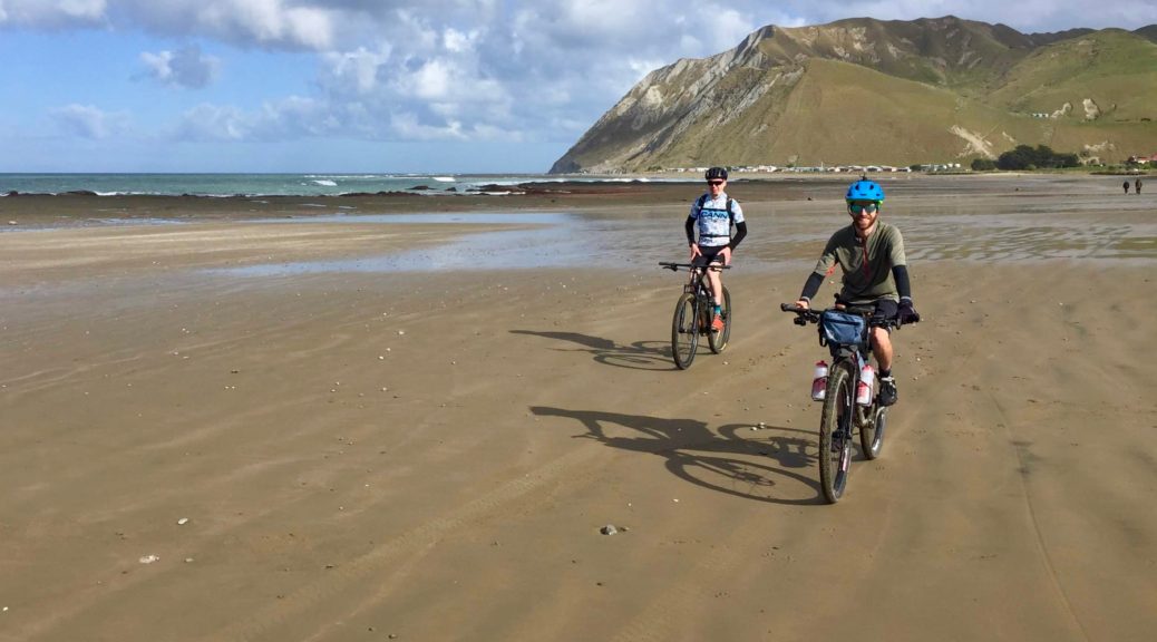
The shingle mostly took us between the hills, but we did eventually climb to about a hundred metres and joined another road back to town. We were but two kilometres from the beach. Josh and I were just persuasive enough to convince Marek to stick with us, see the beach, click over his first 100 km ride with us and we’d get him home somehow – the big climb and headwind may have been glossed over.

Having ridden in on so much gravel, Blackhead Beach certainly felt remote and I wasn’t expecting more than the handful of holiday houses and campground that we found. Having serendipitously timed our arrival half an hour before low tide, the beach provided perfect riding conditions. With that tail wind, the hard-packed sand was far faster than we expected/feared. We flew up the beach.

Grin inducing, in fact.

Marek, and we, celebrated his first ever 100 km ride. A top effort.

Much fun was had.

Reaching Pourerere, ten easy kilometres of beach riding was over and we paused for refuelling and to redistribute loads. I helpfully consumed a huge sandwich. Threats of being deposited in a ditch if it was more than the promised thirty-odd kilometres back to Waipawa hung over my head as we departed. A steady pace over half an hour swallowed up the three hundred metres of climbing away from the coast and gave us plenty of hills, coast and ocean to look at. Another hour of tending down, battling the wind and the odd climb took us over the Tukituki again (downstream of the morning’s crossing) and changing our heading for the final stretch home.

As the long day started to tell over the final few kilometres, the wind eased and a large rain cloud loomed ahead of us – would we make back dry? As I’ve already spoiled that, yes – we did. All pleased to see the cars again, and hopefully I can speak for all in saying that it was a great and satisfying day. Most excellent to have good company join me in trying winter conditions, and successfully put a little more of my route-puzzle together.

Scouting Sunday – West of Wairoa

Since realising on last week’s overnighter that a worthwhile bikepacking route from the south to north of Hawke’s Bay is more feasible than previously thought (as I’ve finally found ways of mostly avoiding the notorious highway between Napier and Wairoa), the idea has become somewhat consuming. I also realised that over the last four years I have built up a little local bikepacking knowledge that may be useful, and maybe there are others that would like to come along on such trips. Suddenly, this little site has a simple new Hawke’s Bay Bikepacking page and there’s a corresponding group. Not entirely sure how that happened, but it’s good fun and hopefully useful.

There’s still a bit of scouting to be done to ensure that the route I’ve mapped out does indeed go. With a fine mid-winter Sunday forecast, I headed north to Wairoa to see just what the roads and terrain are like west of the town. An early start, the twisty, slow dawn drive reinforced that I must try to route off the highway as much as possible. Parking in Wairoa early, the famed Osler’s Bakery was about the only place open – which was handy as that was exactly where I needed to go to stock up on pies for the day. A brisk morning, it was still and quiet. Unfortunately I had thirty kilometres to back-track on the highway; pleasingly, the first little gravel shortcut went through and there was next to no traffic as I tackled a couple of steep climbs.

It’s odd being on the other side of the large bay from where one lives and seeing things from a different perspective.

Looking, over Mohaka Township, to the south of Hawke Bay and Cape Kidnappers on the left, Napier is in the background on the right.

Not quite at the Mohaka River, I turned off the highway and immediately hit a steep climb – so steep the gravel road had been sealed especially. Slowly I made my way higher, distracted by the view opening up to the left.

Back to the Mohaka and its eponymous viaduct. Riding through this area one begins to see why it took thirty years to complete less than 200 kilometres of railway.

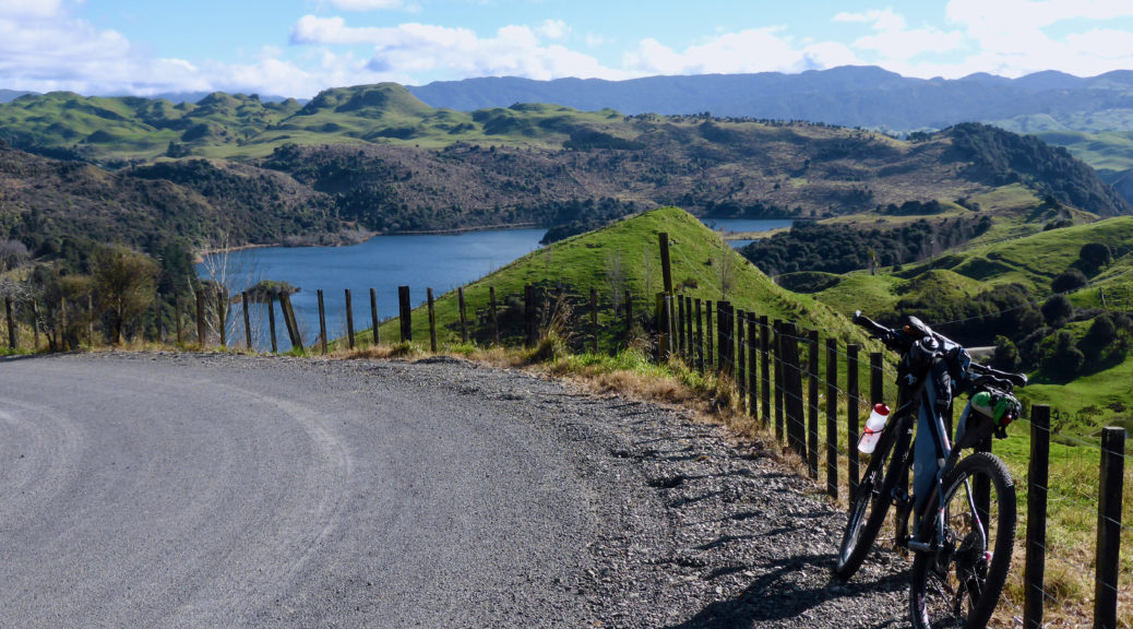
I reached the ridge and the gravel returned – in good condition it was too.

My research indicated that there was an unformed legal road that would take a more interesting route than the sealed alternative lower down the valley. I was surprised to find an illegally locked company gate preventing access, but carried on. Pleasantly the road was top-notch gravel along the ridge – with plenty of little climbs and descents to keep one honest. The pines in there are still quite young, so the views around were good.

Flat-deck Transit, anyone?

An hour off the highway, out of the forest and back on a formed road, I passed through rugged pasture before joining Putere Rd to head northwest – I just had to see if a bridge over the Waiau River was in fact there. If it was, many more route possibilities, including through to Lake Waikaremoana, would open up. Climbing resumed in earnest as the views opened up southwest to Maungaharuru Range. There were enough glimpses through the pines to keep things interesting. Passing Cricklewood Road, which was the real objective of the scouting mission, at around 500 m it was a fast descent (a mix of seal and gravel) towards Lake Rotonuiaha.

The bridge is there – huzzah! Unsure why I doubted it wouldn’t be, a sketchy aerial photo perhaps. I tried to keep my mind on the task at hand and not scheme up wilder and longer routes. They’ll keep, I can’t wait to get back up there and explore more. Lunching at the end of the bridge, a local in a pick-up stopped for a chat (I suspect cyclists are a rarity in those parts) and offered local knowledge of what would be good loops.

Fuelled by another pie, it was time for the grovel all the way back up. It goes some way to show how quiet it was out there, that I was surprised by, not one, but two cars passing me on the climb. I didn’t see any other cars off the highway all day.

Another section sufficiently steep that it had been sealed.

My original plan for the day didn’t include parking in Wairoa and the extra distance that entailed – instead I was to do over two hundred kilometres in the hills, including seeing what is at the end of Putere Road. It turns out, I spent more time taking photos and considering optimal route options than simply riding. So I abandoned that plan, but couldn’t resist seeing if Putere School, marked on maps, was still open. Although the end of the school holidays, it certainly is still a school and only a few kilometres down the road.

Not a bad outlook for one’s primary education.

That distraction over, the rest of the climb awaited; now with the gentle breeze behind me.

Heading back into the pines, I was again thinking of making the route longer if Cricklewood Road was pine-clad with no views. It started out so, but soon opened up with stunning views all around. Although super bright from the mid-afternoon sun, slowing down was necessary to avoid riding off the edge of the ridge distracted as I was by the landscape.

Regular sharp climbs and descents appeared as the ridge was followed. Rounding a corner, horses! Dogs! And easily, a thousand or so sheep heading down the road. Just a typical Sunday afternoon country traffic jam. Avoiding spooking the horse, the riders (shepherds in the strictest sense, I guess) allowed me through to try and make my way ahead of the flock. It took me twenty minutes to slowly make my way through four kilometres of sheep-filled road. A sign of how mild and seasonally-confused this winter has been, the lambs I saw didn’t exactly look new born – and it’s only July.

Soaking in the warm sun, the descents gradually outweighed the climbs and altitude was slowly lost before one final long downhill to the highway.

Mahia Peninsula looking closer than normal – I’ve still not made it there, but hope to finish the route there. Prime Rocket Lab launch viewing spot up here too.

A fantastic day’s riding, I was thrilled by what I saw and found – especially looking forward to introducing the riding to others. Curtailing my optimistic plan for the day was in part done so I could drive a few other roads on the way home and see if they would be worth including. They certainly are, a completely different gravel road: a skinny, twisty, hilly, loose shingle road was another delight before I hit the highway and headed home.

Waikare River S24O

Carl and I never quite found the time over summer to do an overnighter after work one Friday to the Waikare River campground. Finding some mid-“winter” inspiration from somewhere, I decided I wasn’t going to wait until next summer to see what was there.

It’s a long time since I have ridden my bikepacking bike to work; while it felt slow compared to my commuter, to my surprise – it wasn’t really. Maybe the Niner rolls better than I imagine.

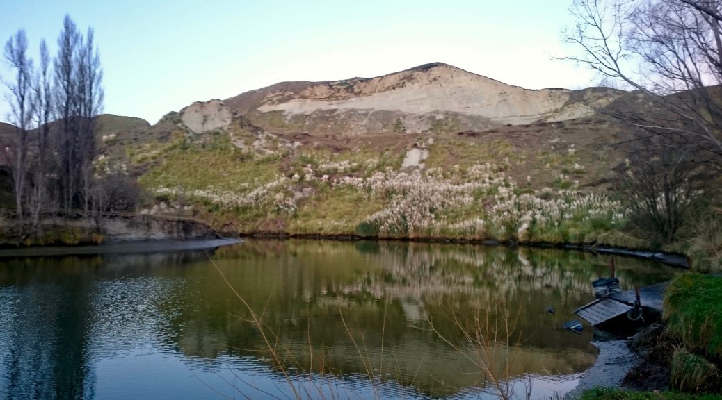
An unusual sight in the bike shed that garnered a few comments.

Starting work early Friday, meant I left early and was well on the way up familiar Waipunga Road gravel (which has really suffered under logging traffic) to meet the store-closing deadline at Tutira. In the late afternoon, the road was devoid of vehicles – I only saw farmer Roy passing on his motorbike. Making it in time to empty the cabinet of remaining hot food, dinner at Tutira was filling – it was even warm enough outside to make a large kiwifruit ice cream viable.

Dark now having descended, I set off on my roundabout route north – avoiding the highway and instead adding an hour’s worth of hills. Always exciting to be riding new roads, even if I couldn’t see much. The clouds were moving rapidly, constantly threatening to bring the forecast rain without ever delivering. A warm winter night, I was very comfortable in shorts and a short-sleeved shirt. Even thought I knew it was there, a 400 m high hill seemed out of place – but it was good fun rolling off it back to a short stretch on the highway (an hour after Tutira). At Putorino I was briefly close to the Waikare before leaving the highway and heading to the coast.

A little climbing was still to be done, before a wild gravel descent to the river. The surface deteriorated and certainly kept one on one’s toes flying down in the dark. Before I knew it I was at the deserted campground. I found the river in the dark and not much else: some toilets, a sink and some taps were the extent of the facilities. A beady-eyed possum watched me set up my bivy bag as the rain finally arrived in the shape of slight drizzle. I settled in for a warm night’s rest, the rain abated and I reflected on a great little ride through the dark after work.

Possibilities of exploring a whole lot of roads between there and Wairoa rolled around my head with the new found knowledge at how accessible this area is. I’d previously ignored it due to the nasty highway, but I now knew that this was mostly avoidable. The schemes continue to grow.

Saturday morning and I could finally see, and wander down to, the river.

I retraced my route back to the store for second breakfast, enjoying being able to see the countryside I was riding through. After keep a herd of cattle intrigued while stopping for the following photos, shortly after I was helping an ineffectual cattle dog (poor thing kept getting charged) round up a small mob of cows and calves. All in a morning’s ride?

Huzzah, the pie-warmer was full of Maketu Pies and as it was so warm I definitely deserved four scoops of ice cream… The strong westerly that hampered my early progress was at my back as I was blown up Darkys Spur, sweltering (relatively) in the mid-morning sun as I was back to short sleeves all round. I took the Kaiwaka, Tangoio Settlement Roads option back to work to round out a fun little exploratory overnighter.

Unable to say no to Anton’s invite to go MTBing, the most fun of the trip was had muscling my loaded, fully-rigid bike up the climbs and around the obstacles of the Mill Block mountain-bike park – whooping in delight at the extra momentum and challenge. A great twenty-four hours, now to get back to scheming how to build on this route.

Pourerere and Aramoana Beaches

Following a short week at work after returning from Niue, the last long weekend for almost five months wasn’t perhaps as appreciated as normal. However, I certainly wasn’t going to waste it! Easing back into Park Run and trail riding gave enough time to scout out a long ride on roads and to places new to me – there are still a few around after my stint living here.

I set off south into a still dawn, eventually catching the sun rising over my left shoulder. Finally something resembling hills appeared as I got further up the Tukituki valley. Roads were deserted and I enjoy the solitude. There was no big horsey meet at Elsthorpe this time as I turned towards the coast. Just before I got back to Kairakau (of the mud-trip), I turned off and finally hit gravel and new roads.

This eighteen kilometre section was glorious. After the initial climb, it was most pleasant valley floor riding through large sheep stations before a decent climb and slight drop to the Pourerere road.

A rollicking descent dropped me down to the beach at the sleepy seaside settlement. There were plenty of great examples of classic Kiwi baches and some fine old tractors seeing out their retirement hauling boats to, in, out and from the surf. I paused for lunch, enjoying the winter sunshine and the sound of the waves crashing.

A gravel bike would have been ideal for this longer ride; that is, until I found at low tide the beach was passable by vehicle to the next village south. I was pleased to have the larger volume tyres as I followed motorbike and ATV track along the soft-in-places sand.

Around the corner I found somewhere else new – Aramoana. I’d not heard of this one, not being steeped in NZ infamy. It was much more manicured and poncy than Pourerere (which with a name that rolls off the tongue so wonderfully, has much going for it). Finding the beach route was a real boon – I’ve often looked south of home on the map and wondered about connecting all the isolated little beach settlements on a ride. Having since been told that with the right tides, one can ride or drive much of the way to Castle Point the schemes are starting to percolate.

Turning for home, there was a bit of bonus gravel back to Pourerere. The only disappointment of the day was realising, while stopping for a bit of cheese, that I’d lost my trusty and well-travelled Buff – it having been on most bike rides with me since the MTB World Champs of 2006. Never mind, I groveled back up the hill and down on some more new road to the Tukituki.

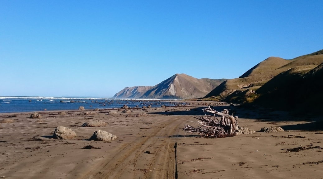
Back towards Pourerere and the Pacific.

Finally I found a reason to stop at the Patangata pub (pie and chips is more than enough reason, really), refuelled and hit Middle Road in the twilight. It was decidedly night by the time I reached Havelock North, the stars providing an ample spectacle as I started to think of dinner. That sorted, it was cycle trail all the way home – thus completing a thoroughly wonderful ride using all available daylight hours. I couldn’t believe how warm it was riding in short sleeves into an early winter night. I was well pleased with new places seen and look forward to finding more.