Excited to be heading into the wilderness, after a large breakfast we stocked up on food for the next two days and hit gravel soon out of Eureka. Steadily heading up the Tobacco River valley, shortly after crossing the river we were on highway briefly and then off it again heading for the hills. As the climbing began in earnest and farms were left behind for national forest, it was expected that we’d be rolling on gravel. Strangely, the sealed road just got smoother as our elevation climbed.
Traveling far lighter than other cycle tourists (they generally had far larger routes planned), they were hauled in at our steady pace. It turned out that there were so many other cyclists, we couldn’t possible remember all their names – over about two days we met about twenty-five others. Some we chatted with for quite some time, some briefly and others just exchanged greetings. Plenty of interesting folk out riding bikes.

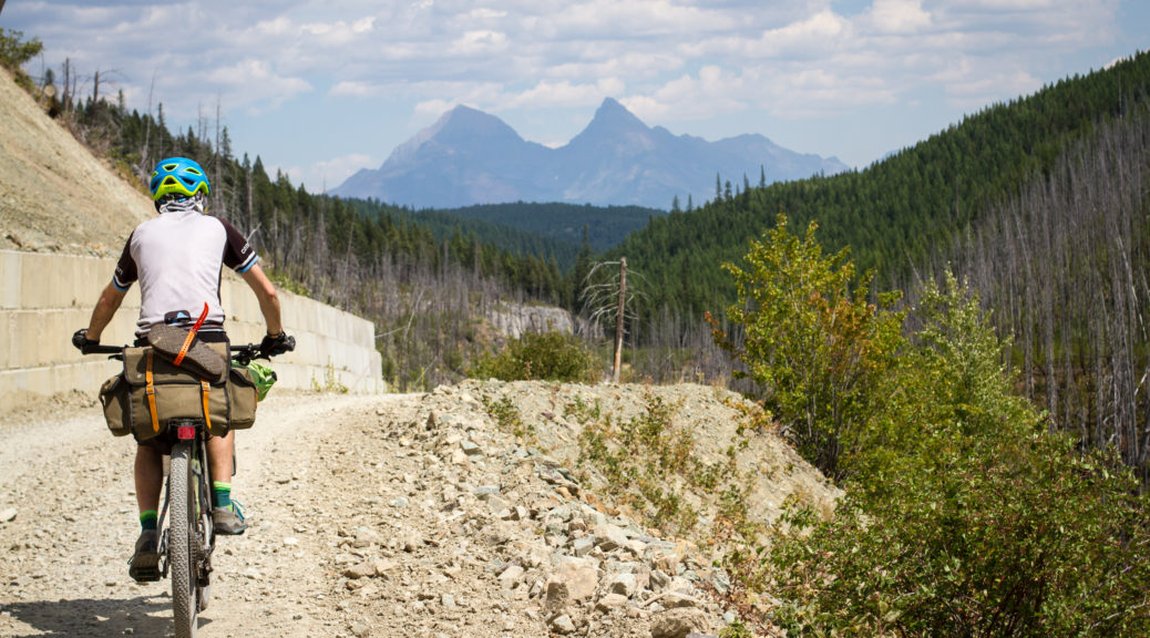
Shortly after meeting some Alaskans, the seal ended and the gravel began – that, I think, was entirely coincidental. A pleasantly warm day, it was nice to be in clearer air than the smoke-stained skies of British Columbia. At least, it meant we could actually see the view in the distance.
 There may have been a lot of trees.
 The surface was fantastic and the gradient mild. Things opened up a bit where avalanches had long since cleared the slopes.
 A feature of the trip was the many different varieties of wild flowers roadside.
 You know, a few more trees. Who me? No, I don’t work for a forest products company, not at all.
Eight hundred metres of climbing done, it only seemed fair to stop at the top of the pass and eat. Also, it would be rude not to chat to more passing cyclists. The downhill was long and also mellow – all the better for looking at the views.

 The west side of the spectacular Glacier National Park came in to view. It was easy to pick the patches of forest that had long since, or recently in some case, been ravaged by wildfires.
 Being in the mountains so much, we were never short of water sources – water treatment drops were used, probably mostly unnecessary but how can one know?
One of the woman from the top of the pass, Sarah, passed us as we stopped to fill bottles. A novice, she was hauling an extraordinary load – worryingly all carried on the rear of the bike. Shortly after, we were confused to come around the corner, see another cyclist standing on the side of the road and some other guy (no vehicle in sight) who must have apparated there . Eventually we recognised Sarah – that was difficult initially as she was covered in an unhealthy amount of blood. She convinced us she wasn’t concussed and the other guy’s family had driven off to fetch her friend – turned out he wasn’t a wizard, disappointing. We couldn’t do any more than had already been done, so carried on – bike helmets really are quite useful.
 The road flattened out as we headed for the Flathead Valley.
It became apparent we were out of the national forest as Private Property and Posted – No Trespassing signs started and we noticed increasing numbers of cabins in woods. Riding south along the Flathead, I’m told it was a lot less remote than the Canadian Flathead.
We never quite sure how many of the cabins and houses were holiday homes, permanent homes or properties of survivalists/preppers. Thankfully the road was still quiet and most traffic, except the FedEx pick-up, courteously slowed for us.
Mid-afternoon we turned away from the Flathead River and started towards Red Meadow Lake – the highest and end point for the day. Stopping again for snacks near a small pond, it may have been the first time we partook of one of the most common delicacies of the trip – frozen burritos. Bought frozen at the start of the day, usually from a gas station, these are much mentioned by GDMBR riders – they gradually thaw and then warm over a hot day, ready to eat heated mid-afternoon (depending on how hot the day is). Another one of those things that taste OK, but it pays not to read the list of ingredients.
A mostly gentle climb up more pristine gravel with even less traffic, it kicked a little for the final section before we rolled ever so slightly down to the lake.

 What a pristine spot for a campground nestled between lakes and mountains.


We shared a campsite with Johnny, a young Swiss guy riding the GDMBR – well, a large part of it in the time he had. Understandably, he was tiring of all the beautiful mountains – not really traveling to see places just like home, he longed for flat, open lands. He was quite taken with how little we were carrying and determined to shed some of the many kilograms he was carrying.
The dust of the day washed off in the lake, local fisherman met, exuberant young dog pouncing avoided and sick of mosquitoes – it was time to call an end to a fantastic day on bikes in beautiful big country. It was much quieter and cooler than the previous night, far better for sleeping.
Thanks to Megan for the photos of me riding.
 Proper decent rope swings; it was not easy jumping off makeshift platforms onto the ropes – great fun but.
 We wound our way downtown, pausing briefly to check out some murals and numerous eels slithering around another stream.
 Down to the coastal pathway, near the infamous Wind Wand – this is about the only thing I remember about New Plymouth from my university holiday job in South Taranaki – it was the topic of much conversation in the smoko room.
 Jacqui, Dan, Adele and James just before heading west on the pathway.
 Passing the port, we rode up towards the base of Paritutu Rock.
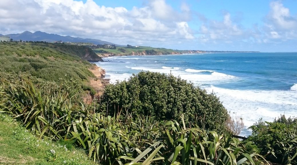
 Atop, we looked out over Sugar Loaf Islands and could just spot some offshore platforms.
 East we looked along the coast, past the port and a disused power station.
 Floating roof tanks! Oh, and the city. I rankled a little bit at the industry-is-ugly comments.
 Hidden in the cloud was Mt Taranaki.
 A little further west we enjoyed a bit of beachside riding – my legs were at least still good for cycling and some nasty little grassy pinch climbs.
 Back towards Paritutu, note the sax player adding a touch of class to our seaside meal.
 The slight detour back into town was unsuccessful in obtaining cronuts, alas; but this building is striking.
 This striking bridge is even more so when the mountain behind us is not shrouded in cloud.
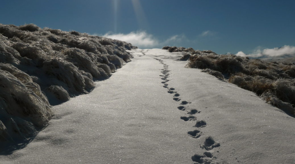
 Not much snow looking south-east from where we parked.
 Across the Maniototo to the Rock and Pillars.
 A tad higher now, at least there is snow on the skin (4WD) track. Looking over to the western reaches of the Kakanui Mountains. I wonder if there is much bikepacking to be had up there…
 We followed these footprints all the way to Buster Diggings, until we finally met two photographers from Dunedin on a day trip. Mt Kyeburn, our destination, in the background.
 Into Buster Diggings – a bit difficult to see the remnants of sluice mining when it’s covered in snow. Once again, Mt Kyeburn in the distance – this time from a different angle.
 Soon after the diggings we rested and snacked at the tiny Buster Hut. Apparently James spent a rather frigid night in here last winter. Well insulated, it was not.
 Looking west over the Ida Range; it looks a bit different to when we biked over it almost four years previously.
 Made it, after about four hours (1636 m); finally proper windy as the Maniototo stretches west behind us.
 Looking over to the Kakanuis from the summit.
 Snow cover getting a bit variable, and the track being pretty rutted made for exciting and knee-flexing times.