Having heard about my attempt to string a big gravel loop together last year and failing to get through to Patoka, Shaun came up with a route on paper roads (legally roads, just not formed as roads – they exist only on maps as roads) to get from the Napier-Taupo highway through to Patoka. The first day of this long-awaited weekend adventure was pretty much the same as the route Steve & I took at the start of last year. The only difference being that instead of the long, beautiful climb up Waipunga, along the ridge before plunging down from Darkys Spur (all on formed public roads – tarseal & gravel), this year’s route would keep us lower down and use more paper roads.
Similar to last year’s ride, we would camp the Saturday night beside the Mohaka River. As I was the only one set up for bikepacking, we arranged the luxury of having all our camping gear and food driven into the campsite by another workmate, Simon, who would go hunting nearby after dropping our kit off. On a fine, warm Saturday morning Shaun, Mark & I assembled at Simon’s house and loaded his car with our overnight stuff.
With bikes lightly loaded, for an overnight trip, we set off just before ten. Over Hill Road to the Taupo road we were shortly ever so slightly climbing up Ellis Wallace Rd – enjoying the warmth and the lack of traffic. As the railway has been closed for a few years, we made a brief foray from the road and rode over the Esk River on the railway bridge, because we could. Due to re-open this year, if just this one bridge is anything to go by – there is a lot of work to return it to a suitable state of repair.
 It was bumpy. Only a few sleepers were missing.

With more gradual climbing on the road, we reached a level crossing and turned right. Big wheels bumping over the sleepers, we followed the rails to the first paper road. And then went past it to check out the first of a series of tunnels on this section of rail.


 There may have been a bit of drop beside the entrance to the tunnel.

 We walked the length of the curved tunnel, not stumbling over any dead goats in the complete darkness.
Retracing our paths ever so slightly, we turned from the railway up a steep grassy hill as the paper road began. For about half of the ten kilometres of this connection, we climbed gently through open farmland on grass tracks. It was very pleasant riding out in the sun, not too hot; we didn’t encounter any stock or a peeved farmer, so that was good. The second half of was through pine forest on a more formed surface. Still gradually climbing, it was nice to be in the shade of the canopy as the day warmed.


Rejoining the road, and last year’s route, it was great to have been somewhere new. A quick ride down to the highway covered another ten kilometres. Turning left we were shortly at the Tutira Store – where the ownership must have changed (it was for sale last year) as the guy behind the counter seemed to know about actual customer service. We had a fair go at emptying the pie-warmer, eating a large lunch in the shade of a silver birch tree. Shaun somehow managed to hole his hydration bladder, but nothing a bit of tape couldn’t fix.
Shortly after two o’clock we set off on the prolonged climb towards Bell Rock. By now, it was definitely warmer than the forecast low-twenties. Mark kept us honest as we climbed and climbed. Without the big mob of sheep to wait for, I didn’t really take many photos – see last year’s post if you’re curious. Gaining about six hundred meteres of altitude, it’s a steady climb and never gets too steep. We started to feel the sun as there was little shade.
 Nearing the top, we stopped at this gateway. Since seeing this picture, I’m disturbed by how skinny my calves look. I’m sure there is some muscle there somewhere.
We finally got to the top of the climb and looked out north in front of us towards Waikaremoana. It was late enough in the day that the side trip to Bell Rock was not feasible. Instead we saw a trig just above the road so clambered up there.
 Looking out towards the Pacific.
 Well, I clambered – Mark and Shaun took their bikes up too.
After being loudly encouraged to get back on the road by a local, we did just that and sped down the gravel road from the saddle. With recent logging still readily apparent, the hills in the distance were more captivating. Back on slightly flatter road, we turned left onto Waitara Rd and the last fifteen kilometres to camp.
First up was a very steep, long, gravel downhill which we sped down – Shaun nudging eighty kilometres an hour! I was glad I still had some energy in reserve as I remembered this stretch of road being a series of steep uphills followed by steep downhills. Exhausting. I had not misremembered this – it was tiring as the legs had to keep on working and the day did not get cooler just yet. Eventually we hit the sealed road again and had a nice little descent to the river to arrive at Glenfalls Campground – conveniently just before our support crew turned up with tents, food & beer.
 Pleased to have finished a great day’s ride. Especially as this was the longest ride on a MTB for both Shaun (left) and Mark (right) – well done guys.
 A few of our little group went off hunting; I was more intent on making camp, eating copious amounts of carbonara, wandering down to the river, and getting an early night after a great day.


 K-Lines!
 Until the previous night, I’d not known there was local wine (very good it was too). The trail had been cunningly routed through a vineyard, past the shop.

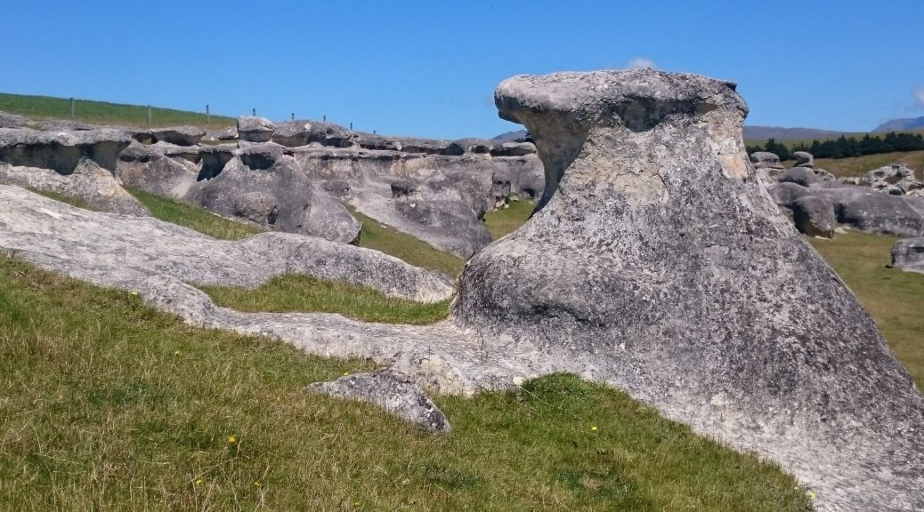
 A destination for boulderers and such people that like to climb things, there weren’t many around that day unfortunately.
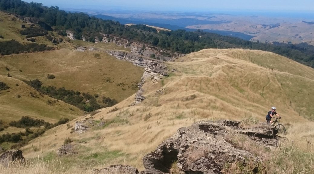
 The trail summited that climb, opening up big views south.
 The clouds were light that day and with the wispy patterns, quite interesting to gaze at as the wheels rolled easily on.
 It seemed less onerous than two years before.
 It was suitably dark and dripping wet – but we found our way just fine to the light at the other end.
 Enfield Church


 Just like that, 290 km of riding in two and a half days was done. A great, easy trail with tremendous views; great riding buddy too.
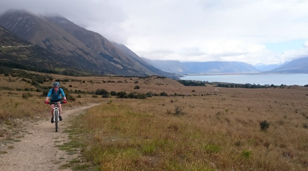

 More lupins, this time bordering a mountain stream. The flowering manuka bushes became more apparent.
 The views of the lake and the Ben Ohau Range improved as we gradually got higher. It was rather a grey day, and the headwind that would hang around all day began to plague us.
 Most of the riding was through open grassland, we saw a few other small groups of riders and as showers passed through we played the on-again, off-again game with our rain jackets.
 Occasionally the trail would cross a larger stream, usually at such places we would ride through a few hundred metres of native bush.
 The manuka became more prevalent.
 Still we climbed, ever so slowly gaining height. Despite the breeze and cloud, it was pleasant riding.
 I stopped plenty to admire the view. Lake Middleton, where we camped, is just visible below the near short of Lake Ohau.
 Eventually we could see a bit more of where we were going. The weather didn’t look any more inviting, especially with the breeze picking up. But it wasn’t cold – so that was nice.
 Reaching the crest of the climb, we paused for a snack and looked down on the trail stretching away.
 The downhill was fast, easy and fun. There were even some convenient little banks to ride up around corners.
 Just as you near Quailburn Road, a new stretch of trail has been built diverting riders up towards a historic woolshed.
 We poked around said woolshed a bit before heading down the road towards Omarama.

 Surrounded by lupins again, it was a long gradual downhill to the highway. However, with the breeze in our faces coming up the valley it didn’t feel that much of a downhill.
 Irrigators stretched into the distance – this one not looking like it’s doing a particularly effective job.


 About to join the highway for a decent climb, I paused at this quiet jetty while the extra bike was packed away.
 Back on a cycle path, we headed towards Benmore Dam listening to the roar of jet boats as holiday-makers zoomed around.
 The last notable climb of the day stood before us – holding back the largest hydro lake in the country.
 That achieved (it’s a reasonable climb, but short lived), we looked out over the boats, the Waitaki River and the hills beyond.
 As the shadows lengthened we followed the Upper Waitaki Irrigation Canal for some distance. Which is a useful segue for plugging Dad’s book.
 A little wander around Kurow before trying to get some sleep – I slept better in the tent.
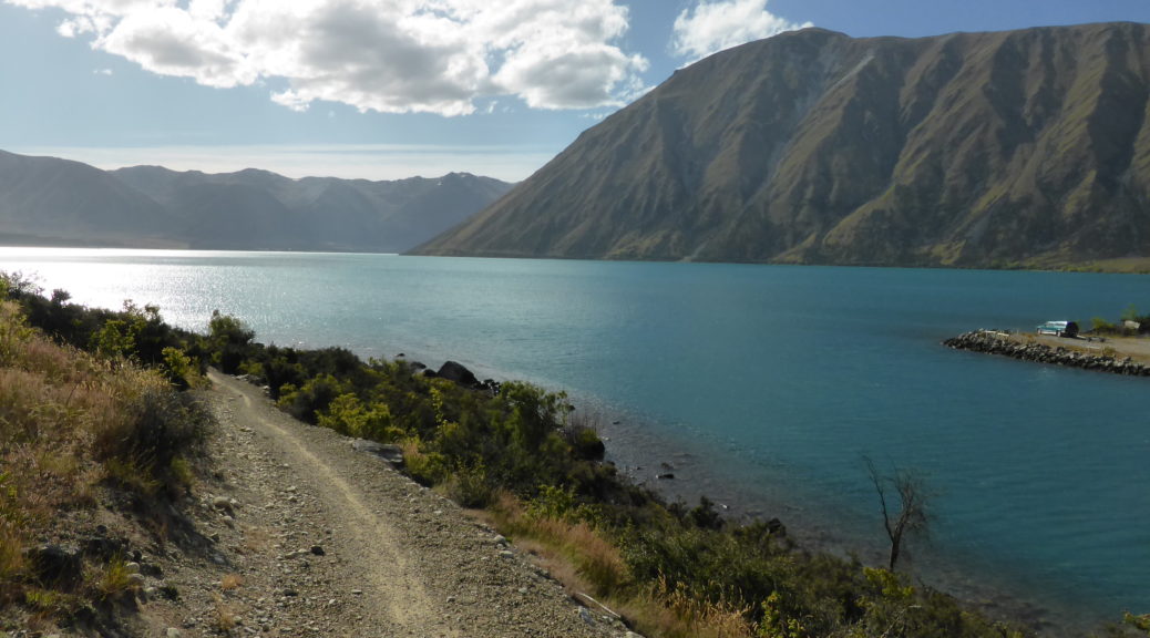
 So much pulled pork, delicious apple sauce and the top of the pie was a very large piece of crackling! Also, scenic lake and mountains.
 About to go bikepacking (sort of) – on full suspension MTBs, with big slow tyres, few & a narrow range of gears, little luggage and most oddly: wearing a backpack.
 The cross wind along here was horrid, we soon turned west to have it at our backs.
 The riding was easy, with a big tailwind we made good progress despite the limited top gear. The mountains came into view.
 It was a good thing the riding was so easy, as the mountains were quite distracting. Mt Cook, NZ’s highest – which Adele has summited, on the right. I got a brief lesson in the names of the peaks and various climbing routes.
 Passing the first big salmon farm (we saw three that day), the canal pooled before entering penstocks down to Tekapo B. We sped down the hill to the shores of Pukaki.
 Following a quiet road for five kilometres, it wasn’t difficult to stop and look back at the Southern Alps.
 Just before the climb to the highway, the route turned off to a lovely trail around the shores. A good time for second lunch – Christmas ham & cheese sandwiches.
 Navigation on Alps2Ocean is a breeze – I had mounted my GPS on my bike, but I didn’t need it at all for route-finding; the signage is extremely good, the moment the thought “a sign would be useful about now” starts to enter one’s mind – such a sign appears.
 Bikes pose with some rather dinky earthmoving equipment at the entrance to Twizel. The assortment stands testament to the massive civil engineering project started decades ago and that still provides a large proportion of NZ’s electricity.
 After crossing the top of the Ohau River, the trail turned to narrower graveled cycle trail.

