Unfortunately, with a week of heavy rain forecast, our long-planned and highly anticipated weekend exploring Mt White Station was postponed. But with another trip planned in tandem the following week, it was still worth heading to Christchurch early to catch-up with friends and attempt to get a little riding in and some fitness back after a strangely inactive winter (unusually wet in Naseby, and winter ills didn’t help).
Andrew and Richard were keen to get out for some rain-riding in preparation for a slightly insane upcoming event; I was happy to tag along as it wasn’t a daunting plan, despite the forecast. A hundred-odd kilometres on the Friday, backpacker accommodation and a pub meal, a shorter return the following day; easy. Meeting in Sheffield after eight, it wasn’t too early for one of the famous eponymous pies. I was surprised how soon the gravel started off the highway (immediately) as we headed southwest towards the Rakaia river under grey skies. I was slow, but had a chance to catch breath as Richard dealt to a flat tyre early on.
 Easy going to start.
New places to me, we were soon through Whitecliffs and on another section of provincial highway. Spotting a “Defence Area – Keep Out” sign, I was a little mystified – didn’t know there was a military base out here, but there was a second sign so I wasn’t seeing things. Off the highway, we didn’t drop to the river – staying on its true left as we headed towards the mountains. Past the top of Zig Zag Rd, things looked a little familiar from halfway throughTTW last year. Easy going with a slight tailwind up the valley.
 Oh yes, I remember this plethora of signs in the middle of nowhere. Continuing straight was new again and took us to Lake Coleridge village and a lunch stop.
There began about five hundred metres of elevation gain, the gradient never really getting above five percent – but my lack of riding was soon shining through, feeling decidedly flat (me, not the hill by any means). This shouldn’t be this hard, but nothing for it to keep an eye on the scenery, continue eating and keep pedalling.
 Across the Rakaia.
 Over the penstocks to the Southern Alps.
Things flattened briefly as we rejoined the TTW route near the end of Lake Coleridge. The Lake Lyndon road was apparently closed for winter, so it was odd to see some inappropriate cars giving it a go – folk from the city looking for snow! It had all been washed away with the rain. Another long slow climb to another lake, the surface being wet and slow didn’t help – but mostly it was a lack of fitness. Richard had had Covid-19 more recently than me and was suffering even more, even I in my state had quite a wait at the lake.

Out to the highway and a short pinch climb up to Porters Pass, before the long descent to Springfield where a hot shower, a pub meal and a miserable excuse for a futon awaited. A good day on the bike, strangely tough for a benign route (good training for something), some new sights, fun company; alas, none of the promised rain.
Just a few hours of easy riding planned to get back to cars, but we’d been told we could ride in the forest at Mt Misery (yippee) en route. This soon became questionable as with the earth sodden from all the recent rain and clearly some big winds having ripped through, there was tree-fall like I’ve never seen in a plantation forest. I’d have preferred to go to the summit, but around the hill we went. Thankfully, the double-track had been cleared of the fallen trees; this meant the surface was both sodden and chewed up. Slow-going, but it could have been a lot worse.
 Just as well I had a sacrificial drivetrain – expecting wet and grit on the West Coast the following week.
 The Defence Area signs made more sense seeing what we couldn’t see from the road on the other side of the valley floor the previous day. Munitions dumps, cue too many memories of reading about process safety incidents, design and the hierarchy of controls.
Eventually we got out of it and climbed on decent forestry road.
 Reward for the little climb and slow surface.
 Best example of the storm damage in there.
The fast descent off the hill was much appreciated and we were back on the roads to Sheffield, and another pie. Sodden farmland everywhere, looked like a tough winter as some paddocks more resembled swamps. Malvern Hills Rd strangely wasn’t hilly, mostly just skirting the base of said hills. Done by lunchtime and back to clean up, eat, and rest. Still none of the promised rain.
Sunday I’d arranged to catch-up with Mark, hopefully over a gentle two or three hour ride. But agreeing to take the passenger ferry across Lyttelton Harbour to the notoriously hilly Banks Peninsula the writing was on the wall; Grant arrived just as we boarded, by then it was in screaming capitals. My first taste of bike riding on the peninsula was going to be very climby.
 But with a day like this…
 The calm before.
The sealed climb out of Diamond Harbour passed quickly enough in the cool of the morning and with plenty of chat; maybe a bit too fast. Soon the drop to Port Levy – the only place I’d previously spent any time in the area, a few days of eating, sleeping and barely moving trying to overcome the fatigue and limping post-TTW. I certainly didn’t spend those days riding up four-hundred metre climbs back to back.
 Down to Port Levy on the climb out.
By the second summit, I was done. I could either turn back now alone and retrace my steps, or continue with three more climbs (the next the toughest, the following the biggest) with Mark and Grant. Riding alone was not the point of the day, but I’d only brought snacks for a few hours. But encouraged by word of a pub lunch and plenty of snacks to be shared – the choice to continue on a glorious day to see some new places in fun company was the only one to be made. I’d be slow, but I’d get there.
 Down to Pigeon Bay.
The Pettigrews Rd climb was, I was told later, not the easiest way to the Summit Rd – but at twelve percent for over half an hour, it was not as tough as the impression I got of it beforehand. Still, I lagged. The reward, delayed by ten minutes of riding along the ridge, was the Hilltop pub and a lot of tasty food (even chicken chips/crisps, which I generally detest, tasted good) soon disappeared.
 View to Akaroa Harbour wasn’t bad either.
A fresh descent of Harmans Track was over in a flash, to leave us with the slightly less steep, but much longer and higher climb up Western Valley Road. It certainly went on, but with all that food I wasn’t falling so far behind. Unfortunately the drop back to Port Levy was a bit mucky with recent forestry traffic, but fun all the same before the last four hundred metre climb of the day had us back at Diamond Harbour with time for refreshments before the ferry back across the harbour.
An excellent introduction to Banks Peninsula riding, I survived and hopefully got a bit of bike-fitness back – plenty of food certainly helps. Thanks Mark and Grant for the encouragement and all the chat.
That was about the riding for almost a week around Christchurch, I must return for some more. Special thanks to Jo and Andy for such generous hospitality.
 A clear start to the day, but it hadn’t been cold overnight.
 Hut getting smaller; Rachel’s photo.
 Bit of a switchback, waiting patiently for the sun to strike the corrugated iron of the hut. Alas, as slow as progress was hiking up the hill – it wasn’t slow enough.
 After gaining two hundred metres in half an hour, the Cromwell Cardrona Pack Track became old 4WD track and surprisingly rideable.
 Well, there was still the odd steep part. The ridge behind, part of the previous day’s route (left to right).
 We started to get glimpses of snowy peaks in the distance.
 Andy in his element setting up for more videoing. Nevis Valley way off south.
 Mt Aspiring making an appearance.
 The climbing pretty much done now, we had quite a descent to look forward to. About 1400 metres, wahoo!
 But first, someone insisted (ahem, me) that we should walk up to the highest point of our trip – Mt Dottrel – as, when would we be back?
 A steady climb to the flat top, the first real bit of downhill we’d done that day behind.
  I think it was worth it. Cromwell down below with Lake Dunstan and the Cairnmuir Mountains behind. Old Man Range on far right, we’d go over that low point between the two later in the day
 Mt Dottrel at rear.
 The southern end of the Dunstan Range – must get up there.
 A rut! Quite a surprise. Rachel’s photo.
 Even this newspaper clipping was dragged out – not the last time we were told that day of Rambo’s demise. After
 There was much enjoyment to be had on the Pisas picking out places the three of us had ridden together recently. Here the Chain Hills, Dunstan Saddle, the Lauder Conservation Area were visible in front of the St Bathans Range. Still more places to return to or explore for the first time.
 Into the farm we were supposed to be on, finally!
 Occasionally spaniard plants aren’t making me yelp in sudden pain, the spikes seen indicate why they often do.
 Twas a fun and fast descent.
 Rachel’s photo.
 Up the Kawarau Gorge; soon, I’m told, there will be a cycle trail down there to connect to Queenstown. That’ll be cycle trail all the way from Middlemarch! Will just remain to connect it to Dunedin.
 Getting lower. Over to Bannockburn, the start of the Nevis Road, the Old Man and the afternoon’s route over Hawksburn Rd.
 Picking out the sheep tracks that I “ran” up and down on last year’s Mt Difficulty trail half-marathon. What was I thinking?
 You wouldn’t pick it, but this photo is for the slight view of the Pisa Range and where we were just an hour or so before. Quite satisfying sitting eating looking at that, exclaiming “we were up there”! It was fantastic after all.
 Eating, the real reason we go bikepacking. Also notable for Andy’s remarkably clean shirt (Clean Shirt!), bought just for being vaguely presentable in Queenstown. Rachel’s photo.
 Hawksburn Farm in the sun, Old Man Range behind.
 Some of the last climbing for the trip, relatively easy going.
 Undulating across the saddle, there’s the end of the Dunstan Range again. One day…
 Finally, one last, steep downhill back to Mark’s place.
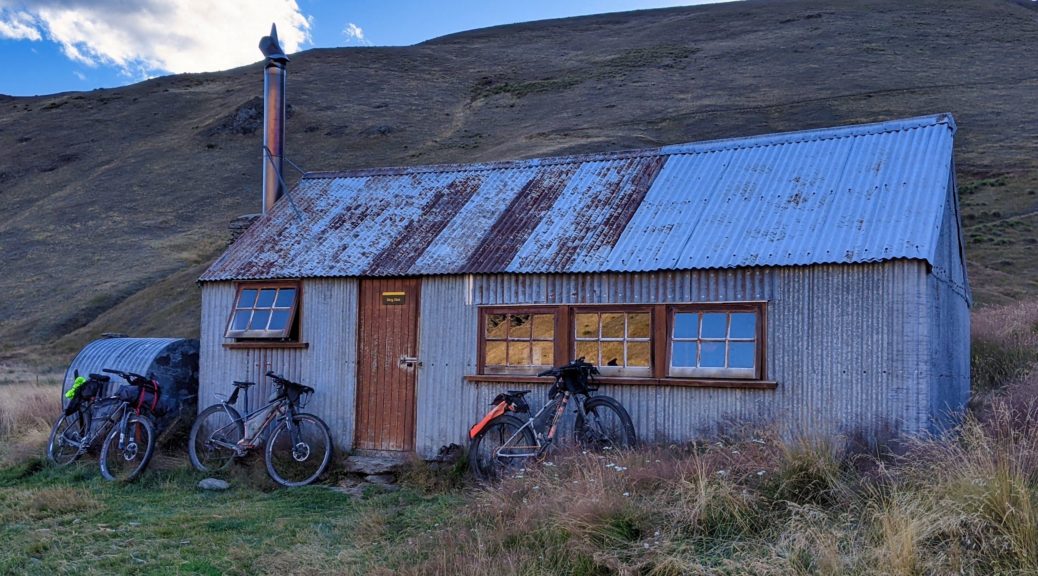
 Ok, one food picture. Not my usual breakfast while bikepacking, or any time at all. Delicious.
 Certainly was worth waiting for skies like this.
 Over the old Shotover bridge, past a head on the river flats, and looking up to Coronet Peak.
 Back towards Queenstown with a little more elevation.
 I spied a turnout and wanted a better view, letting the others get ahead. Down to Gibbston.
 Strangely empty road, apart from the two bikes that I now had to chase down.
 Rachel’s photo.
 Mt Cardrona, not much of a ski field at this time.
 Spaniards smell remarkably like pine cleaner. Who knew? Well, we did as Andy had been telling of it on the previous trip. Rachel’s photo.
 Things kicked again, but more rideable than I thought.
 Towards Quartz Knoll, the highest point of the day, as we approached Mt Allen.
 Somewhere over there, hidden, is the hut we were looking for.
 The push up to Quartz Knoll, looking back to Mt Allen. Nevis Valley, from the first day of the trip, way off in the background.
 Standing on Quartz Knoll looking southwest-ish to Rock Peak (left, midground). The Airways installation to help passenger jets land at Queenstown visible.
  East to the southern part of the Pisa Range, it would keep until the following day.
 Time for the Type I fun to start – fast, rocky, open descents.
 More climbing, of course, on typical ridge riding.
 Plenty more ridge to go before dropping to Tuohys Gully. The roads to and of Snow Farm and the Southern Hemisphere Proving Grounds (testing of pre-production cars in winter) visible on right.
 There’s a hut down there! Not ours though, although that track at the back is also for the following day’s climb.
 Aha, there’s our hut! One last fun descent and even a stream crossing.
 Adorable wee hut, and we had it all to ourselves.
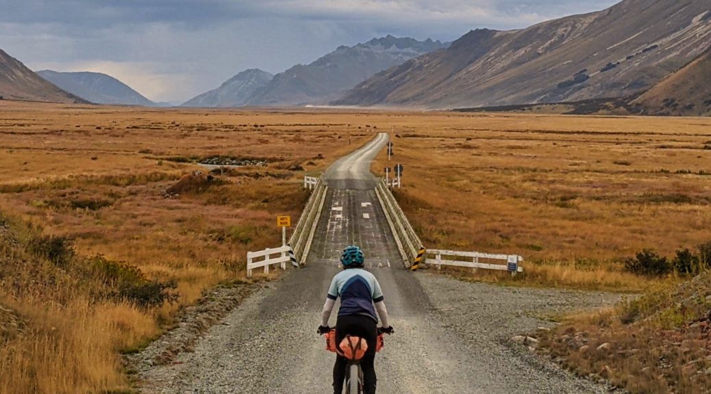
 A little bit of valley to go.
 Easy morning riding, fun times.
 Rachel’s photo.

 Nice to have the time to finally stop and nosey around this old cottage. In remarkably good repair, it looks as though it’s used for occasional dinner functions. Probably in pre-pandemic tourist times.
 Walter Peak towards the right of that ridge.
 We managed to get a late morning tea here while the smells of openly slow-cooked barbecued meat wafted through the restaurant. Pity we’d not booked lunch and a later sailing!
