Category Archives: GPS

Kiwi Brevet 2015 – My Day Two

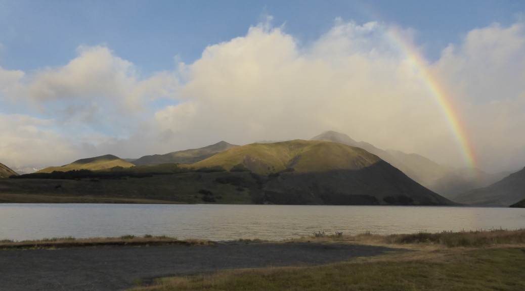
One can’t complain too much when you wake up in the wilderness with views like this:

I had a leisurely start to the day & managed to eat the rest of my dinner that I couldn’t the night before. The other two were off well before me, so I spent most of the morning riding solo. Back on the route, it was soon the turn off to the St James Cycleway – part of the NZ Cycle Trail. I’ve ridden a few of the easier trails that are part of the network further south recently, but this was a whole different level and was actually mountain-biking – it was incredible.

First up it was a decent 250 m climb on 4WD track up to Maling Pass, at just over 1300 m. The views looking down into the Waiau were more than worth it, and the very fun fast rocky descent to the valley floor was excellent.

From Maling Pass looking down to the Waiau.

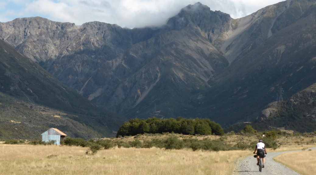
This was definitely an intermediate grade trail down the valley – a lot of fun, but at times quite hard work with a loaded bike. Sometimes it was just following small paths across the grass on the river plains, at other times the purpose built trail had to climb a bit away from the valley floor – some of the pitches were so steep they required walking. At one stage the river valley narrowed to a steep-sided rocky gorge – so there were some wire swing bridges to cross, not always the easiest with a heavy bike and certain peril staring you in the face.

Most of the way down the valley, an ominous black cloud had been chasing me – thankfully it never broke completely, but the light rain that fell had a nice cooling effect as the day warmed up. It started to get pretty hot, & I made a point of drinking a lot – but still struggled to fight off a little nausea. After quite some time I finally caught up to some other riders – I think they’d had a much earlier start than I did. Turning east it was up over Charlies Saddle (more pushing) to go east up the Edwards River valley. That was manageable, but climbing out of that to Peters Pass was a solid fifteen minute push at gradients over twenty percent – hard work & I was starting to get a little fed up. At least there were a few other people around – some struggling like me, others depressingly riding a lot of it.

At the top of that climb the pass turned to an easy grade trail down to the St James Homestead. I cruised down that, wondering how much longer I would be able to go on, as the others all took off for Hamner Springs – which I was very much looking forward to seeing. The trail at ended at the homestead – it would be great to do it one day on an unloaded trail bike. Jacks Pass was a bit of a non-event, much to my relief, before a screaming 500 m drop down into the hot spring resort town of Hamner – it was nice to see civilisation again. I was so exhausted I spent about half an hour lying on the grass in the shade of big trees in the centre of town as the drizzle continued to fall. Back in phone coverage, I was able to pick up a couple of short encouraging messages that had been left, which did untold wonders for my spirits and determination to finish – I made a deal with myself that I’d complete this day & the next before making any rash decisions like pulling out or changing to the Brevette (which plenty of people had been doing).

With a bit of food, here I discovered the brilliance of salt & vinegar crisps (they’ve always been my favourite – but there restorative properties, mainly helping with salt levels, were new to me), and after a good rest I was ready for the fifty comparatively easy kilometres on highway to Hurunui. I took it easy, but being on the road my speed was well above the average for the rest of the day. At Culverden I came across a small group just setting off again after a coffee stop. Somehow I managed to hold on to the back of that group as Dan set off at quite some pace for the last fifteen kilometres to Hurunui (where I had planned to get to that night, at least). We stopped for a swim in the Huruni River and enjoyed the warmth of the late afternoon. With some good company, a swim and then the pub stop my Kiwi Brevet was back on track and saved – I was a happy camper again.

Kiwi Brevet 2015 – My Day One

The event briefing over quite early we had a lot of time to kill before the ten o’clock start. Never really one keen to stand around and talk about bikes and compare set-ups, there was plenty of time to find a supermarket and get a second breakfast (the large one provided by my exceptional hosts, Shirley and Doug, had somehow faded from my stomach already) and do a little stretching. Eventually it was time to assemble.

Seymour Square – the night before, prior to be filled with bikepackers. No Cycling signs – what No Cycling signs?

We set off in a light drizzle that persisted for hours, but was never really that bad. After a bit of road west out of Blenheim, we crossed to the north bank of the Wairau and followed it upstream on a gravel road through a big forestry block. A few days later and we would not have made it through here as the forest caught fire and a lot of land was burnt through. The pace was pretty quick in the bunch of about a hundred (I think the split was about 70% 1150 km Brevet, 30% 750 km Brevette), much quicker than I would normally ride. Following a big wide river valley up, it was generally gently climbing up with the the odd steeper up or down.

It was all very pleasant with plenty of people to talk to, I tended not to stop at all – which was not a great idea. Crossing back over the river we had a short stretch of highway into a nasty headwind before turning south into the Rainbow Valley. This was more gravel road gently (mostly) going up the valley – it was grand & absolutely spectacular as the mountains got bigger and slowly closed in. The light rain stopped and I paid my two dollar toll to get past the gatekeeper in plenty of time. I started to feel a little peaky at this time, but took it slowly & kept going.

As we climbed to the saddle before descending to Sedgemere Shelter, I started to feel a bit better. As it was still well early, I couldn’t bring myself to stop after my planned 150 km for the day (doing around 150 km per day should get me back by Saturday afternoon – although I’d only ever ridden that far in a day once, I thought that was achievable over ten to twelve hours). So with a bit of food on board I carried on up to Island Saddle, the highest point on the course at a shade over 1350 m. By this time I was riding with Oliver, a cycle tourist from Somerset (of all places) and Dean from Dunedin. I did it pretty tough on the climb up to the saddle, but eventually we were there and it was a nice blast down the hill – we turned off route for a kilometre and all feeling pretty tired camped at Lake Tennyson the night.

I think I overdid it a bit that day with the initial pace, not eating & drinking enough on a long & hotter-than-it-seemed day and not stopping enough (only twenty minutes stopped in almost ten hours). I was exhausted and dehydrated to the extent that I couldn’t even keep a few mouthful of water down at one stage. Eventually I managed to eat about a quarter of the rather tasty freeze-dried Thai chicken stirfry I’d brought along before collapsing into bed for a night of sleep broken by some rain and some strong gusts of wind roaring off the lake. That’ll teach me for not sticking to my rather conservative plan.

Buster Diggings – Johnstones Creek Track epic

One of Adele’s teammates for the upcoming adventure race, Garry, thought that a good training MTB ride for Adele would be the Buster Diggings & Johnstones Creek Track combo. Naturally, I thought this was a great idea as Central Otago is beautiful and riding bikes is great. It’s not a well-known trail, not even making it into the NZ MTB trail bible (Classic NZ MTB Rides), so we were a little taken aback as we checked it out the night before. Over two and a half thousand metres of climbing in sixty kilometres?! It looked like it would be a long day – especially as Adele has not spent much time riding recently.

Consequently, it was an early start for the eighty minute drive to Naesby (which I am assured has great MTB trails in the forest – but I’ve not ridden there, yet) to meet Garry. Having arranged a car shuttle we left town & managed to drive a few kilometres up the Mt Buster road before setting off on our bikes – Adele taking her brand new one for its first outing. It was a glorious day and the first few kilometres along the undulating gravel road were pleasant riding. Before long we were entering the Oteake Conservation Park and the first of three tough climbs began. Progress slowed markedly as it took over an hour to go 3.5 km and climb almost 600 m! The surface was pretty good (all of the day was spent on double-track/4WD track), with just one particularly rocky & loose section causing me to push my bike for a hundred or so metres. I had plenty of time to take photos while I waited, so here are a few of typical Central Otago hills & plains – the hills invariably covered in long tussock (a type of grass found in the high country around NZ).

Entering the conservation park, looking ahead to the first big climb of the day.

Part-way up, looking south over Central Otago.

In that pick-up are the only people we saw all day – we were out for over ten hours and only heard birds, streams flowing & the breeze (apart from any sound we made obviously). It’s quite remote up there.

Eventually the hill plateaued and we got some respite. We took a small side trail to look at Buster Diggings – the result of the highest gold mining ever undertaken in NZ at 1200 m above sea level (Otago had quite a gold rush in the nineteenth century).

The results of alluvial mining, and Mt Buster in the background.

A lot of our hard work was undone as we plunged off the plateau down to the head waters of the Otematata River below.

After the quick descent, we followed the small river for about fifteen kilometres. Often we had to cross the river – I lost count of the number of river crossings we made, probably up around twenty. All except three were rideable with the current level of water in the river. Before another climb started, we stopped at Tailings Hut for a bit of lunch. Somehow twenty-six kilometres had taken four hours – I think we deserved some food and a bit of rest.

A typical NZ back-country hut – and Adele’s brand new bike no longer so clean & immaculate.

From the river, it was another steep climb around the end of the ridge – but this was much shorter before plunging to the river for another crossing. Unfortunately, at the high point in this section we could look across the valley and see what was to come.

All the downhills of the day were great, and not just because they were such welcome relief.

Yes, another opportunity to get one’s feet wet – by this point Adele was quite soaked due to a previous unplanned dip further up the river.

That was a small part of what was to come.

This was the most brutal climb of the day – six hundred metres up in only five kilometres along. The first half was noticeably steeper than the second, but the surface was very good and it was all rideable for me. With the sun beating down, it was getting hotter as the we were sheltered from the wind. Regrouping on the next plateau, the riding got easier – but was still generally climbing.

Waiting on the plateau amongst the tussock.

Eventually we came across the second hut of the day – the Ida Railway hut. Originally down on the railway that was converted to the famous Otago Central Rail Trail, the old station was somewhat unbelievably hauled up the route we had just ridden some decades ago for use as a musterers’ hut. I was pretty thrilled when Garry pulled a large slab of Christmas cake from his pack (he was wearing the large, for mountain-biking, pack that seems to be standard equipment for their team in the adventure race). It was good cake and excellent to be sitting out in the sun in the wilderness with great company enjoying it as the stream babbled close by – especially sharing a big bike adventure with my sister.

The climbing reared up a bit more across the plateau as we got to our highest point so far that day – about 1550 m. Across the plateau we could also look north to the Southern Alps and pick out Mt Cook (NZ’s highest mountain) easily.

Looking back across a small part of the plateau we’d ridden across. For perspective – if you look very closely you can just see Adele rounding the corner at the right of the shot.

Depending on whether one was climbing or descending (for me, at least), unfortunately & then fortunately (respectively) the trail condition got a lot poorer from this point on. The Canterbury greywacke stone used to pave the route suddenly became much larger, looser and more sharply edged. As I alluded to above – this was fantastic on the next steep plunge as the riding became much more technical and thrilling.

But after that steep plunge, we were left looking at this:

About a quarter of the last climb of the day…

While not the toughest, biggest or longest climb of the day – due to the poor surface it was definitely the most technically challenging. Starting off at the bottom I was starting to feel a little tired, but from somewhere found some energy and managed to ride all but about a hundred metres when it just got too loose & tricky. Whether going up or down on the chunky loose rocks, I found it much easier to carry a bit more speed than normal to avoid getting bogged down in the greywacke.

Finally we were at the magic point of no-more-climbing, looking out across Central Otago again. All that hard work in the sun was about to be rewarded by a glorious, fast descent dropping 800 m in five kilometres. That was even steeper than what we had climbed – I would not recommend riding this route in the opposite direction considering the surface at the west end. I know the other two didn’t really enjoy this rather technical, steep downhill (Garry had been preparing us all day to be disappointed with it after all the work taken to get there) – but I was grinning all the way down. So many big rocks moving all over the place, plenty of water bars to jump off and a grand view.

You can just see the trail snaking its way down from the right of the Hawkdun Range.

With a few more miles to ride down on a gravel road to where Garry’s car was waiting for us, there was plenty of time to savour the biggest, hardest and most-epic day mountain-biking I’ve had in ages. If even obscure trails like this that I’ve never heard of are so good, that bodes well for the rest that this country has to offer – perhaps I’ll be able to stay, now I just have to find a job sometime.

Les Granges – through another’s eyes

Sort of a guest post today – well, I’m still writing but all the photos are Zuza’s. Previous posts during my stay here at Les Granges have centred on activities away from the vineyard and winery – mostly because I don’t tend to carry my camera when I work and therefore don’t have many photos to write to. But Zuza likes to carry a camera around often and has somewhat become official photographer for the few of us that have been working together for the last two or so weeks. It’s also interesting to see things that I see every day through another’s lens – plus she’s a much better photographer than I am. So, with minimal words hopefully, here are some of the scenes of my stay here.

Nightly serenade.

Every so often the aged family dog makes an appearance struggling on tired arthritic eighteen-year old limbs.

A little slice of home.

New house (still in progress) and winery on left.

Netting up to thwart the hungry birds just before these grapes are due for harvest.

Cleaning vats in the winery.

Pressing grapes by foot.

Edo and the small vessel used to ferment a little – this is then added to the larger batches of wine to kick-start them.

Pizza night.

And some from our hike to Col de Malatra, near Monte Bianco, last week:

Tasty, tasty ham.