Just the slightest spits fell overnight, we rose to a gloomy morning with the sandflies rampaging again. Immediately crossing the Lindis, it wasn’t one of those where you can get away with dry feet – leaving us with cold feet for much of the day.
 Leaving the headwaters behind, no sight of Melina Ridge this morning.
 First climb over to Smith Creek to try and warm us up.
 Into another one.
Ninety minutes of pottering past more yards, another private hut and we were soon grovelling up the highway to Lindis Pass. Twasn’t even a mile to roll down before finding the shortcut that would save us some altitude loss and regain to take us to the pylon service road which would be our next hour or so.
 Heading south, we got some patches of sun.
 Twas lumpy, to say the least.
 Occasionally the sky corresponded with the last forecast we’d seen.
 Another conservation area demanded more food – unsure if it was second-breakfast or first-lunch, but there was a good bottle-filling stream.
 We joined what was supposedly a road, Goodger (great name), but was not really much different to the tracks we’d been travelling on over the hills – win!
Sometimes we spied, and tried to pick out, the Lauder part of the Dunstan Range that we were heading for. More obvious was the Chain Hills that were right beside us, and originally part of our route – as the day wore on we were all pleased we hadn’t gone up there too. Yet another great return option, probably on a big day ride – that ridge riding looks fantastic, but exhausting. Instead we continued across farmland, and up and over small ridges into the next valley.
At the foot of the next big push, we deliberated over the route. The more-direct one Andy had plotted had No Public Access signs posted. There was no one out there so we could probably take it with no issues, but as was pointed out – this wasn’t the way to go and much work had been done arranging the public access there was. We turned around and headed upstream towards the Chain Hills. Past more yards and another private hut, the track was all grass and steepened – it was slow and tedious going.
Reaching the point where we’d sidle around the foot of the Chain Hills, we did at least find signs that further clarified some of the many more possibilities for exploring out here.

 The sidling wasn’t much better, but nothing compared to the next section.
Dropping to and pausing to refuel as Cluden Stream, the next push uphill was the toughest of the route. Steeper, it was far more overgrown with long grass – but the wheels still turned. To our utter surprise, the climb then had a bog running down it. Surely bogs are on flat land where water can settle – not cascading down a mountain side? Feet soaked again, there was still hope we’d get into some sunshine by late afternoon.
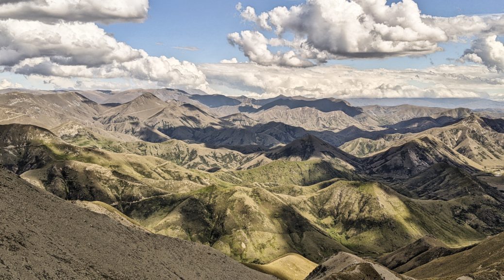
Eventually the track dried out, the gradient lessened and there were no more switchbacks. Out on the ridge we had views over to the Alps, where we’d come from that day, Dunstan Pass and the Chain Hills, and St Bathans Range looming behind.
 That’s better.
 A bit of sun for the day. Andy’s photo.
 St Bathans Range in the background, in the middle Dunstan Pass on the left and further right one of the Chain Hills tracks.
 Much the same, but now the rocky tors had begun to appear as we gained hundreds of metres gradually along the tops.
 We’d come from somewhere just in front of that small patch of snow.
 Many tussocks; looking out to the Alps around Hawea.
 Quickly, the low cloud that we had seen sitting over Central Otago blew through on the southerly that had been cooling us much of the day.
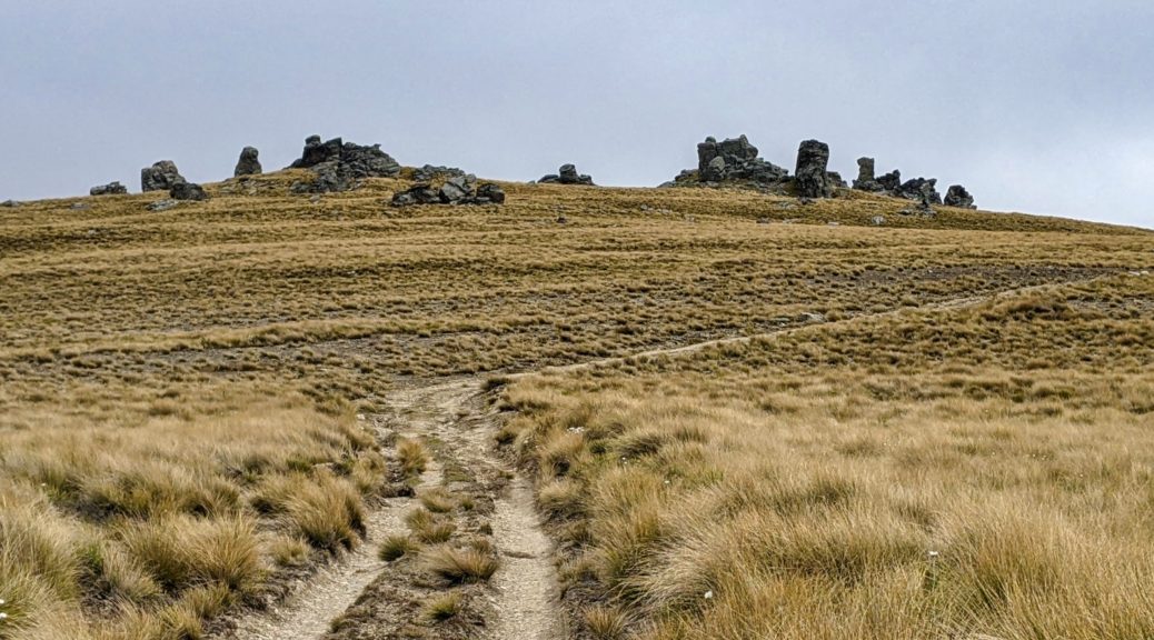
 Still we kept climbing to more and more rocks.
 Now getting above the level of the Chain Hills, we were making progress.
 Mistakenly waiting in the lee of a big rock thinking that was the top. Sigh…

 Cold enough for jackets and thick gloves. At least we’d made the top; although whizzing down would be even colder. Andy’s photo.
 Over the Manuherikia valley in Central Otago – I’d ridden through there the week before.
 Time to start dropping 1200 metres in quick time; hands cold from stopping too much to goggle at the view and take pictures.
 The usual Spot the Track – fun and fast descent.
 Only the week before I’d ridden Thomsons Gorge and wondered about exploring the hills extending either side of the pass and now here I was looking at it from those very hills. Huzzah for having the time and flexibility to say yes to such riding opportunities that just come along – more of this, please!
 A snippet of the big descent into and through Lauder Station – fun and fast farm track riding.
Having far too much fun, I soon resumed my gatekeeper role – which gave the opportunity to regroup. A long day, some said as tough as a TTW day – I’m unconvinced, I was given the extra job when stopped next to call ahead to the Vulcan in St Bathans to see if they had rooms and would keep the kitchen open. That was easy enough, the manager was most agreeable, there were two spare bunk rooms and they’d rustle up some food for us – it’s improved so much from my memory of it, now that the management has changed. That just left a big hillside to get off and half an hour of gradual climb to the village.
 Made it in plenty of time where we were well looked after – even if some of us almost fell asleep eating the large meals!
For the second day in a row, I was absolutely blown away by the country we’d been able to travel through and take in. Perhaps more astounding was all the other opportunities apparent for future adventures. Two days in and already I couldn’t say which was my favourite.
 Across Lake Benmore from the dam remembering previous trips on that lumpy pylon access road.
 Across the dam and there’s now a trail up there, instead of going through Otematata down at valley floor level.
 Looking over Otematata Station to the Hawkduns brought back memories of stinking hot days
  I was thrilled that this new section of A2O took us high above the lake to give views of parts I’d not seen before.
 Still surprised at just how green this normally barren area is looking this summer.
 Almost another hour up the wide valley, getting closer to the access easement.
 Andy’s photo.
 Stunner, hot afternoon.
 We were advised to cross the Avon Burn as soon as possible and stick to the farm track, much easier going than the nearby poled route.
 The track soon left the stream with some steep pinch climbs.
 As we got into the hills, we constantly pondered just which track we would soon be ascending. Andy’s photo.
 We found this sweet, old private hut just before the long push began.
  Looking up to the big switchback, that was almost halfway up the total climb.
 Back down Avon Burn, the hut near those yards.
 Looking south before switching back and crossing that face two pictures above.
 Running out of words for a while.
 I can see at least eight tracks there I want to explore!
 Into Otago now and the start of the Lindis River, we’d be down there soon enough.
 Waiting a bit, scoping out more tracks.
 The trail changed for the last few kilometres to the summit, with a little dip around the corner to climb out of.
 Tough place for fenceposts.
 Through the gate into our first conservation area, I was not stopping on the downhill that presented itself.
 Another climb from that stream did at least give a good view of the bottom part of the descent. One can see the Mt Melina track, that left the ridge track at its highpoint.
 Out of Oturehua on the Otago Central Rail Trail.
 Starting the climb, over the Manuherikia Valley to the Raggedy Range.
 For once I had the time and inclination to make the small detour and check out this wee old hut. A pleasant spot for second-lunch.
 Thomsons Saddle.
 Headwaters of Thomsons Creek, the stone hut just around the corner.
 One day, hopefully soon, I’ll go up there. Now I’m in the area, there are many little side trips to be found and explored.
 The restored Come In Time Battery.
 Over the Lindis River.
 Heading to Cornish Point.


 There’s the occasional climb, but nothing significant on a loaded bike.


 As well as the scenery, which was probably not helped by the gloomy day, I enjoyed having the time to read all the signs detailing history and engineering in the area.

 Saying goodbyes.
 Actually stopping to read the interesting displays at Lauder.
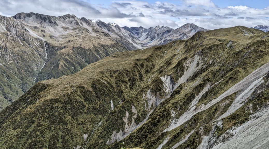
 Riding around the bays east of the city was a pleasant, if blowy, afternoon.
 Some inadvertent hike-a-bike to get here.
 Evening run up Mt Vic.
 Actually got warm on this big walk – but perhaps because I was dressed for the previous weather, which I don’t have photos of.


 Some shelter for a late lunch.

 Towards Otira.
 Plenty of Mt Cook lilies out.
 Yup, blowing a gale up here.
 Down the Taramakau valley to the Tasman.


 Some deserted forestry roads gave few views, save this one.
 A strange collection of long-abandoned short lengths of wood.
 Across Lake Brunner from Moana – tasty late-lunch stop.
 Through the farm, heading for the beech forest.


 The first of three tunnels – thankfully there was a bypass.
 This one far more conducive to riding through.
 I had a few stops on the way down to go for short walks, well worth breaking the drive up.


