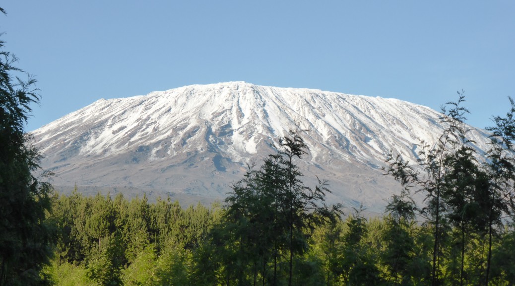
An important factor in rather suddenly deciding to come to Tanzania for three weeks was the opportunity to do a four day bicycle tour around Mount Kilimanjaro. I’ve discussed the possibility of climbing Kilimanjaro (at 5895 m the highest mountain in Africa & the highest free-standing mountain in the world) with numerous people over the last year, but each time the six days needed (at least, to allow for altitude acclimatisation) and the expense have counted against it as I’d rather spend the time and money I do have riding bikes. I’ve since been told the trek is more beautiful than imagined, so perhaps one day…
To save the ten-hour uncomfortable bus ride from Nairobi to Arusha, I flew into Kilimanjaro International after a change of planes in Ethiopia. It was a cloudy morning, so we couldn’t see much in the distance on approach – this made it all rather strange as a large 767 was put down seemingly in the middle of nowhere (the airport isn’t exactly near a town, in between two distant towns, Arusha & Moshi). An advantage I’ve found with flying with African airlines (EgyptAir & Ethiopian at least) is that they still have the large baggage allowance of two bags that North American airlines used to have – so my bike travels free and I still get to put another small bag in the hold, it makes packing and transferring so much easier.
Over a evening dining and watching rugby with friends I tried my best to stay awake after the overnight flight and little sleep. Somehow, my bike got assembled rather quickly the following morning as four of us went out for a short local ride – great fun finding trails that local villagers must have been walking over for generations. Parts of the landscape reminded me of the Badlands in both Alberta and South Dakota.
Due to other commitments, we missed the first day of the EduTours Africa four-day biking tour around Kilimanjaro. I didn’t mind too much as it was a short day of riding (only 27 km and a net ascent of just over a hundred metres) and I figured after the riding in August, I was probably still fit enough to cope with the rest of the tour. However, this did mean we had to get up at 4.30 the following morning to drive two and a half hours to the first night’s camp. By the time we arrived at Lake Chala, which is bisected by the Kenyan border, everyone else had eaten breakfast. Adrian and I had a quick look at the picturesque lake (in a crater) before eating, although I suspect the overcast skies detracted a little from the view – but it’s a beautiful place to stay all the same.


Before long, we were all on our bikes and heading up the camp driveway back to the road that would take us anti-clockwise around the mountain – that was covered in cloud. The others, Grant and Catherine – a wonderful couple from western Canada, had ridden down this hill the day before so knew to expect a 200 m climb back up over 7 km. The dirt road surface was good and riding in the countryside of a different country is always interesting – it was very rural with plenty of crops recently planted and many small banana plantations.


Once that initial climb was over, the rest of the first thirty kilometres was spent at about the same altitude – so it wasn’t too taxing as the day warmed up. There were plenty of locals out on the road and adjoining paths (which were so tempting to go & explore) on foot, motorbikes and ancient bikes carrying all sorts of loads. At one snack stop Gab (one of the two guides on the trip but on Landcruiser duty for the day) had a go on such a bike. With no pedals, minimal brakes and the load, he found it rather difficult!

 Bike posing with our support vehicle – both remarkably capable over such terrain.
 At this junction, the route turned up the hill for a 250 m climb up to lunch – thankfully the road became less corrugated than it had been for a few kilometres.
 Past more banana trees.
We found ourselves in a small town, Mashati, on a busier sealed road and lunch was served. As I got used to over the few days – the food was great and plentiful for cycling – how Francis, the cook, managed to do so with such a basic travelling kitchen I’m still unsure. As well as plenty of meat, fresh fruit and veges there were ample carbs – on this day in the form of pasta & potato salad. While we ate, a heavy shower passed through the area; we waited it out and set out on the busier-than-a-dirt-road for the afternoon.
Before long the rain had returned and set in for at least a couple of hours; seldom heavy, it was persistent and we were all pretty wet – some more so than others. With more traffic there was a lot more to look at in this respect, especially as the landscape turned to forest from fields, and despite the rain all the locals were still out. Strange people riding strange bikes always seemed to be a source of amusement, especially for the children, and we exchanged many greetings and the few Swahili words we knew and many more phrases in English that the locals had learnt from somewhere and delighted in using somewhat out of context.
 Still smiling.
As we got closer to the mountain, the road naturally kicked up a fair bit. Grant and Catherine were both in their early sixties and, while not regular cyclists, have found that they love to include a supported cycle tour on their travels to see different parts of the world. So while the 68 km and 1600 m of the day on roads was easy for me, especially with an unloaded bike, the afternoon’s pace was very slow & steady. But I was impressed with their fortitude and the turning down of the option of loading the bikes on the trailer and driving when we entered Rongai Forest as dusk approached & it was still raining. Eventually we arrived at our camp for the night, Snow Cap, under Kili just as it got completely dark – I’d left my lights at the house, thinking there was no way we’d have such long days.
After a pleasantly warm night camping, we awoke to find clear skies and finally I could see that Kili was actually real.


 With a bit of oil on chains, we were soon off again.
The day’s riding started off fantastically as I found some nice singletrack through a forest next to the steep gravel road we’d climbed to finish the previous day. We were soon back on the sealed road, but nicely there was still little traffic on it – the traffic really dropped off when we’d passed near a border town the day before. It was only 24 km of seal, with a couple of hundred metres of climbing to start off with as we got near 2100 m and approached the Kenyan border before riding parallel right next to it for some time. It was a non-existent border on the ground – the only way I knew it was there was from looking at the map on my GPS.
At first, the plantation forest had been clear-felled and the locals had already cultivating the land with vegetable plots. The pine forest returned before we came across a lot of indigenous forest – in which we saw some Colubus monkeys and baboons.
 A Colubus monkey, coloured rather like a skunk.
 Back in the pines, AD spotted a augur buzzard.
As we descended rapidly, paths through the forest attracted attention and it was easy enough to go exploring some singletrack alongside the road before returning to the route. It was nice to break the sealed road up a bit and burn extra energy by taking these slight detours. Through another small town, we were back on a dirt road for the rest of the day – & this is where the day got really enjoyable. As well as a more bumpy surface, which at times near washes deteriorated noticeably and made for fun riding downhill, the villages became smaller and we were amongst a Maasai tribe – whose brightly colored shuka (the blankets they wear) are always attractive. Being more rural & less busy, the people seemed even friendlier as we passed people going about their days and children at school. Unusually for the Maasai, owing to a disastrous drought some years previous, this particular tribe has learnt to grow some crops.
 It’s a reasonably flat football pitch, I suppose.

As the gradient turned to a more undulating one and the forests were gone, the views out over to Kenya really opened up. We spent most of the time gazing over Amboseli National Park; known for its elephant population, some of them have been forced to come up towards Kili looking for food due to recent droughts – a huge pile of elephant dung was spotted on the side of the road.
With fun little downhills, some off-road excursions for me, and manageable climbs we continued on in a mix of cloud and sun – with a slight breeze, it was perfect cycling weather.

 Returning to the road after finding rocky trails and a herd of goats.
 Frequently I waited, occasionally I posed for photos.
 We went back into the forest again for a while.

 A few tractors started to appear to help plough the fields.
As we started to get a bit peckish, the Landcruiser passed us and went and set up lunch on the side of the road. Another good spread for hungry cyclists looking out over the road to Amboseli stretching before us.


Continuing on we rounded the base of a hill I was glad that we didn’t have to climb, and seemed to leave the Maasai lands behind. With a brief stop around the time we passed land that was being farmed commercially, we looked back to see a big black cloud starting to dump rain over a small area behind us.

Said cloud started to move towards us and I felt the first few drops. The road stretched before us and just freewheeling I quickly found myself in front of the others.

Faced with the very real prospect of the heavens opening on me and me being many minutes in front of the truck and my rainjacket, I decided I had a fair chance of beating the weather to the campsite if I rode fast enough and didn’t stop. Maybe I wasn’t that concerned, as I spent a lot of time riding next to the road on long sections of singletrack. Passing through a very large herd of goats crossing the road, I was back on the road for the rest of my riding day. As the black cloud and large drops continued to menace me, Simba Farm Campsite popped up on the screen of my GPS & I was saved – which was just as well as there was no sign on the side of the road. I rolled down the more-used dirt driveway to a house and established with next to no Swahili that I was in the right place; just as I put my bike under a lean-to, the rain began tipping down and I ran to the house mostly dry.
It is the short rainy season at the moment, but unusually early, so the rain was only supposed to last ten to fifteen minutes. But it stretched on rather lengthily for close to three-quarters of an hour, before finally stopping – at which time the rest of the group that I’d abandoned turned up absolutely soaked and covered in claggy mud from the driveway. As the day was about sixteen kilometres shorter than we’d been told, we arrived with plenty of daylight left so after the others cleaned up we had time to wander to a brilliant sundowner spot.
Simba Farm is vast – about 7500 acres/3000 hectares, and in an absolutely spectacular setting. They run sheep and beef, and grow wheat, barley (for the local Kilimanjaro lager), beans and vegetables for supply to lodges and shops in Arusha.
 The western end of Kili hiding as the sun set.
 Mt Meru from the opposite side to which I’m used to seeing it.


Ambling back down the hill after the sun had gone, we found that our drinks order of Kilimanjaros and bottles of wine had been delivered (the main lodge is five miles down the road). Sipping more well-earned drinks the sky cleared as we spotted various constellations and the Milky Way and a stunning full moon rose over Kili. I thought I ate a lot of another grand dinner, but I woke at three on a warm night absolutely famished. This was surprising as the day’s riding wasn’t particularly onerous – sixty-eight kilometres again, but with only about half the climbing (about 850 m), a net descent (about 250 m) and a third on sealed road. But maybe I should just eat even more, it all seems to disappear somewhere – mad as it seems.
When I was awake in the middle of the night, it had clouded over – but on getting up just after six, it was clear again so we walked back up the hill to see the sun rise over Kili.
 Shira, the lowest of the Kili’s three peaks – at 3962 m it’s a lot lower than the highest summit.
 The sun starting to hit Meru.

 The sunlight making its way onto the stunning jacaranda trees, as we wait for breakfast.
With only about fifty kilometres to ride on the fourth and final day of the trip, it was about nine before we set off – thankfully, the driveway had dried up overnight.

The first twenty kilometres of the day was excellent – trending downhill on fast dirt roads, that were nicely rutted in places to make things fun. All day the stunning views of Meru continued over to our right. The first major village/small town we hit was an interesting sight with it bustling with life and all the shops and services so different to what the Canadians were used to. The welding on the street side, primitive tyre shop, butcher and so forth were things we’d seen before – but not all together in such close proximity with so much life buzzing around.

For ten kilometres, the surface became rather corrugated – & at the slow, steady pace of our group it became a little tedious. But large wheels sure help, as did occasional off-piste excursions to find smoother surfaces. For morning (rather, noon) snack stop we finally got a group photo – although Kili is hiding again.

To finish the four-day ride, it was sealed road losing a fair bit of altitude passing through more villages. For kilometres either side of large villages there was an excellent path beside the road that I delighted in bombing down, weaving back on to the road whenever there was a small bridge to go over, hopping off things and just generally stretching my legs more than I had the previous hours.

We passed through the village that Gab grew up in & rather fortuitously met his father crossing the road (there were a lot of people milling about, so it was quite the coincidence); it was market day, so people had come from the hills all around to sell various produce and firewood.
 Millet drying in the sun – a not uncommon sight on our last section of the ride.

With not nearly as much traffic on the sealed road as what we’d been warned about, it was a nice ride down to our finish point the road we were on joined the busy road back to Arusha. With bottles of Kilimanjaro and other favourite local lagers, we celebrated the four-day trip around Kili that Grant & Catherine completed (I’m still so impressed, I sure hope that I’m still riding mountain bikes around the world when I’m in my sixties) – in total it was about 215 kilometres with close to 3000 metres of climbing. AD & I did a little less than that after having missed the short first day.
With lunch over, the bikes were loaded on the trailer and we headed back to Arusha – what a great ride with so many different sights of this wonderful country. I still maintain that bikes are one of the best ways to explore new places – you see so much and can still interact with the people and landscape so much more than in a car. Thanks AD for inviting me along, and special mention to Carm who stayed at home with the kids while we were off having fun and adventuring.


 Nightly serenade.
 Every so often the aged family dog makes an appearance struggling on tired arthritic eighteen-year old limbs.
 A little slice of home.
 New house (still in progress) and winery on left.

 Netting up to thwart the hungry birds just before these grapes are due for harvest.
 Cleaning vats in the winery.
 Pressing grapes by foot.

 Edo and the small vessel used to ferment a little – this is then added to the larger batches of wine to kick-start them.

 Pizza night.


 Tasty, tasty ham.


 A very dirty glacier way off in the distance.
 Down the valley from which we started – Monte Bianco hiding briefly behind clouds.


 Traversing near the top of the valley.
 Monte Bianco on the left.
 There’s the trail heading up to the pass – which is the narrow gap on the right. There wasn’t a lot of room to have lunch.


 I really wanted a bike as we got back into this valley – the trail was sublime.


 The pictogram of a pilgrim that often was the trailmarker daubed on posts.