Triple Peaks – finally

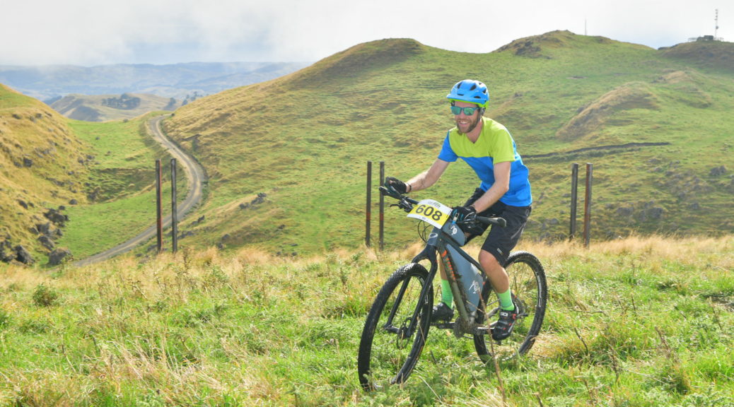
Since moving to Hawke’s Bay near on four years ago, I’ve heard much of the long-established Triple Peaks event. It seemed to have a reputation as a punishing race (MTB or run) climbing three peaks (obviously) near Havelock North. As two of the peaks are on private land, this event is one of the few chances to ride all three. I fairly regularly ride up Te Mata Peak and had been fortunate enough to ride up Mt Erin with a group – which just left the tallest, Mt Kahuranaki, for me to check out.

Unfortunately the weather had been dire the previous two years, and with the Tukutuki River running too high the reserve course had to be used – removing Kahuranaki from the event. One of those years it was so wet, Mt Erin was removed too and the race just went up a very slippery Te Mata three times. Keen to see new places, I’ve always reserved my entry until the weather forecast was likely to allow exploring of somewhere new. This year was finally that time; I entered a few days beforehand.

The days leading up to race day were dry, so the river was low and the A-course was good to go. A little rain overnight before the start greased things up just a bit. It had been a long time since I’d done an actual race, and I certainly wasn’t in anything resembling race-mode (whatever that is) – I’d chosen my bikepacking bike and left the frame bag on so I could carry plenty of food for the fifty kilometres, which I hoped would take me about four to four and a half hours. I found a spot near the middle of the field as 120-odd riders waited for the seven-thirty start.

That wasn’t a great idea, I should back myself more, as climbing gently out of town on seal I eased past many people on much bigger bikes – bringing numerous comments about a motor being hidden in my frame bag. I was in no rush as we started the climb of Mt Erin on farm tracks. It certainly was greasy and at times, with the particular tyres I had, it was easier to get off and run through sections of mud and slop. At least I wasn’t on a cyclocross bike – that looked miserable.

Suddenly the track we had been following ended and the course had us carrying and pushing bikes up steep, slippery grass slopes. I wasn’t quite expecting this level of hike-a-bike, but without luggage my bike seemed very light – another bright side. Settling into the adventure, I admired the view over the Heretaunga Plains as it opened up.

There was a camera, so I got back on my bike.

I stopped longer to admire the view, and found the doctor to snap a picture of this close-to-home adventure.

The music emanating from near the transmission tower drew us closer. I may have stopped a while longer to listen a bit.

Just your average piper and drummer on top of a hill at eight-thirty on a Saturday morning as scores of people rode and ran past.

Off Mt Erin on a rigid bike was just brutal. The tracks were rough enough, but crossing steep paddocks threw me all around and slowed me – plenty of people passed me. But that was only ten minutes of bouncing about before a winding trail through some riverside scrub led to the river crossing. With the Tukituki only knee-high, it was a fairly easy carry and rather nice to cool off a little. Through the aid station I’d no need to pause before a short section of road and farm track led to the bottom of Kahuranaki.

I was surprised when Shaun, a colleague and much stronger rider than me, caught up to me and chatted for a bit – surely he was well ahead of me. I’d not recognised him bent over repairing a flat at the bottom of Mt Erin. Climbing around the back of Kahuranaki was a steady gradient of ten percent, the surface was mostly good and I made steady progress. Nearing the summit, loud tunes were blasting down from a huge sound system – this was certainly motivating and took one’s mind off the climb. Cloud rolled in and it got quite misty very briefly, I enjoyed what of the view I could see. Only just below the summit did the hike-a-bike start, picking one’s way through boulders strewn down the slope.

Another camera, time to hold onto mine and get back on the bike.

With a last scramble up to the trig and a tentative carry off the very peak, it was more bumpy crossing of pasture before finally reaching a well-maintained track. The descent turned fast and wild. Forty-one minutes up, thirteen down. It was fantastic fun; made somewhat exciting on the bi-directional part of the course where some people couldn’t grasp the concept of keeping left. Never mind, it was exhilarating weaving at pace through those hardly moving.

Through the river aid-station again, it was encouraging to hear a couple of familiar voices cheering above the rather loud drums (not of the highland variety). Another familiar face was a marshall at a point halfway across flatter farmland. It is nice to see such people unexpectedly in the middle of events. A stretch of quiet dead-end road had us continuing our route paralleling the river, before we turned away and sharply rose through another farm. More ten percent gradient and more pushing.

Back on the bike, we approached the final peak, Te Mata, from the opposite side to that which I am used to. Some familiar spots led to the Back Track, which is normally walking only. Well, going up, it was still walking only. More of a goat track, it was narrow and numerous switchbacks led up the steep slope. It was easy enough to push up it, but at almost twenty percent it was not a climb I’d be riding up anytime soon – I’d definitely not be able to negotiate the corners. I was happy with my progress and energy levels still, every so often I’d haul someone else in and then expect them to pass me on the descents – they didn’t anymore.

With time for a brief drink at the top, familiar trails beckoned me back to town and the finish. Still bumpy on MTB trails, I held on and pointed down. Thankfully we didn’t have to survive the original MTB track – there would have been significant carnage. Instead, flying down the road for a bit, we hit the flowy trails to Chambers Walkway, a brief bit of road and then some more singletrack before the final road section. To my surprise I still had plenty left to pedal hard and get back in four hours and eight minutes.

Even more startling was that I’d got home in tenth place in a field of a hundred and twenty. I wasn’t really expecting that, and perhaps should have not faffed around so much with photos and admiring the view. Never mind, it was a great morning out on the bike seeing new places and views. With far more hike-a-bike than expected, it certainly was a challenging ride – but I loved it and was proper impressed by such a well-run and iconic local event. Definitely worth the wait.

Great Southern Brevet – (half) Day Seven – Kurow to Lake Tekapo

With a mere hundred kilometres to knock off, I did it tough and slow on my final morning on the course. Turns out the playground I slept in, well attempted to sleep in, for four hours was near an intersection used by many trucks the night through. In Kurow, who’d have thunk it? That and the strange bivy-bag claustrophobia was enough to have me up and rolling before half-five.

Up the Hakataramea Valley was a long gentle climb; I pootled on knowing I’d get it done, but with no real energy left after the previous days of effort. Getting lost and wasting energy in those trees may have slowed me more than I thought. At that hour, the roads were at least quiet.

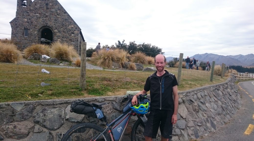
Dawn wasn’t too bad either.

I paused for water and a snack at Cattle Creek, the hall looking rather disused and the school long since closed and abandoned. But here the gravel started and that was cause for celebration, muted though it was.

It really was a lovely morning, and the wind-gods must have felt sorry for me – there was little to contend with. The road curves left and climbs to the pass on the left of Mt Dalgety.

Nearing the pass, naturally the gradient kicked – but it had been very mellow up until that point.

It really was a nice day, Mt Cook and the Southern Alps hove into view.

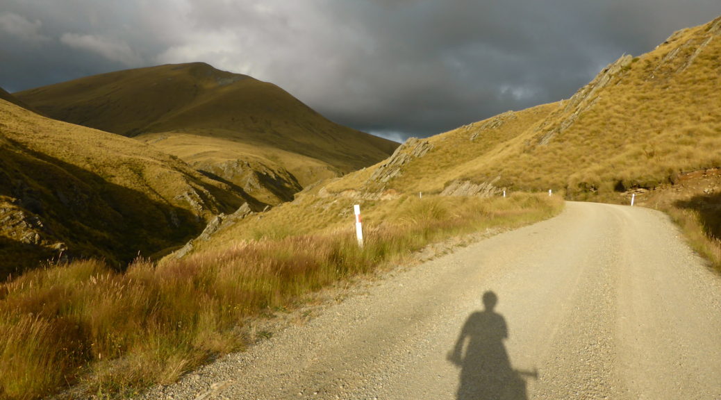
Finally, I reached the pass. Rather unhurried and tired, somehow sixty kilometres and 800 metres of climbing had taken five and a half hours! Never mind, it would be all downhill from here – surely.

Yes, a long downhill!

Reaching Haldon Rd, there was only thirty kilometres to go and Lake Tekapo lay off in the distance. I could see it down there! But gradients can be deceptive and both Haldon Rd and the highway busy with traffic (each sharing the remaining distance near-equally) had a nagging gentle climb in it. I pushed on knowing that I was lucky to be escaping the headwind that gave this section notoriety amongst the other riders.

With the confidence of it being a question of when, not if, I’d finish this ride kept me going at a steady, albeit slow, pace. Sure enough, I rolled back to the Church of the Good Shepherd six days and change after having left. Unusually, and delightfully, for these events, there was a small welcoming party. I’ve seen it written that I looked pretty fresh, but I know and the photo below suggests that is far from the truth. That was certainly a tough week on the bike, but through some amazing parts of the country and thoroughly worth the effort. About half I’d seen before, but I was more than happy to see those parts again to faciliate exploring new places.

Big thanks and much kudos to Dave for organising it all and planning such a great route. I can see why people keep returning to this gem of a ride (despite or because of the conditions?); knowing that the route varies each time I can see I’ll be well tempted to come back for the next iteration(s). Great to meet so many and ride with a few for extended periods, special mention for Steve and Jake as we battled through that wind together. Thanks also to my parents for picking me up, putting up with me for a weekend of much rest and eating, and then dropping me back in Christchurch; also to John for the Christchurch base and airport transfers.

Last word must be about the wind. For three years, my yardstick of wind strength when it gets a little tough has been “well, it’s not as bad as coming into Bluff on the Tour Aotearoa when I was reduced to pushing my bike alongside a flat highway into 100+ km/hr gusts for eight kilometres in eighty minutes”. No more. Now I know: if I haven’t been blown off my bike for four days in a row, it’s not really that windy; or if I am not holding onto my bike as it does its best impression of a kite being blown away with each gust – it’s also not really that windy.

Great Southern Brevet – Day Six – A Linnburn shack to Kurow

Having called it a day in the southerly storm, got warm and then, with nothing else to do, slept well before sunset – it was a fitful night’s sleep. I must have been quite exhausted, as my bivy bag was markedly more claustrophobic than it ever had been. But it’s real purpose was to keep decades of dirt and pigeon droppings off, so it was simple enough to open it up and relieve the anxiety. Leaving our humble digs shortly after half-four, we had a bit of lost time to make up.

Clambering back over the fence, we were back on gravel for much of the morning. As the sky lightened, we climbed a couple of hundred metres. This section was off the Old Dunstan Rd route proper, but knowing the real route slogs up and over farmland steeply I was not quibbling with Dave’s routing. Short of water, we refilled out of a canal below the Paerau Weir, which feeds power stations I didn’t know were there.

Rejoining the Old Dunstan Rd, the big climb I remembered well loomed into view. As the day dawned, it was definitely cooler than last year. Progress up the ten percent gradient for an hour was slow and steady, but seemed easier. There may have been some walking, perhaps I’m blocking that out.

The weir, the road we’d just ridden and out over the upper Maniototo Plain.

Jake powering ahead again.

Reaching the high point, still heading into the southerly, and seeing all the snow down to our level I was well pleased we’d called the previous day early and avoided the exposure up this high. It was cold and bleak enough as it was.

Dropping down to the Loganburn Reservoir, undulations tired us and took us towards another ridge. Knowing that we did not have to go up the Lammermoor Range and instead were turning east away from the headwind was a great comfort. That there was a big, prolonged descent that really shook me up was quite good too, even if it was interspersed with some decent pinch climbs. Out of the desolate tussock-clad hills and into productive farmland, we lost seven hundred metres and finally turned to have the wind behind us.

This was off the Old Dunstan Road and took us on a quieter more direct route north to Middlemarch, where we knew breakfast, brunch and lunch were waiting.

There was of course a steep climb waiting for us through Rocklands Station.

Joining the highway north after some ridgetop riding, the wind pushed us the twenty kilometres to town. I was happy to be off the highway for the last third; that is, until we found major resealing work on the gravel surface was in early days. Early enough that the gravel had been laid for kilometres, loosely graded but definitely not compacted. It was awful, but with energy that would soon be topped up we powered through.

Finding the only cafe in town certainly didn’t take long. Much to my chagrin we were ten minutes too late for a full English breakfast, I may have been somewhat fixated on such a thing for the previous six hours. Still, there was still plenty of delicious food to fuel us to our next stop.

Bacon and egg pie, broccoli salad, green salad, couscous salad, two spinach & feta parcels, tea for two, a chocolate milkshake and bottles of water…

That didn’t last long.

Breakfast/brunch/lunch over, we promptly rode around the corner to buy snacks. I may have also had a particularly tasty ice cream too while having a delightful chat to a senior about bikepacking, hearing how intrigued and envious she was about our rides.

The logical way out of Middlemarch for Ranfurly would be joining the rail trail at its southern terminus. But Dave had us on gravel roads that I’d not ridden before. For some reason I had plenty of energy and was feeling pretty good; mostly, I think it was the tailwind. I quite enjoyed the hour on the gravel road only climbing gradually as we headed up alongside the Taieri.

Crossing the river, joining the highway and then climbing away from them both, finally we joined the traffic-free and smooth rail trail. I waited for Steve and Jake, to briefly impart a bit of local knowledge about Naseby, before leaving them – I didn’t see them again until the finish at Lake Tekapo.

Joining the rail trail at Hyde.

Weaving and dodging plenty of cycle trail tourists, the gentle rail gradient sped by. Strangely for me, I had the hammer down and made good time – an easy riding surface and that lovely tailwind. Based on my expected progress, I was pretty sure Ranfurly would be the last open store I would pass before finishing. So I made sure to stock up for the twenty-four hours ahead, before following one of the few routes into Naseby I was unfamiliar with.

The route called for a singletrack section in the Naseby Forest. Due to fire risk, that had been closed for the previous days and those ahead of me had mostly not been able to ride it. But the closure had been lifted, so my progress predictions were set back a bit as I enjoyed some slower riding through the trails and beside the water race. But I still had enough time to stop for a cuppa, eek a little charge into my dying phone, arrange with family a pick-up and to book somewhere to stay and rest before flying home.

Leaving town just after six, it was a glorious evening and I was looking forward to riding riding over Danseys Pass – in the northerly direction, for the first time. After I’d stopped at the renowned pub for a big lamb shank, of course. The wind pushed me up and over the deserted gravel road in lovely warm light.

The pinch climb after the lavender farm slowed me some, but soon I was dropping down to Duntroon and the Waitaki River as darkness descended even quicker. By now it was near eleven o’clock and I was thinking I should make Kurow – maybe even beyond – before getting some rest. If I got past Kurow, I might be good for my longest-distance day (anything over 270 km would do) and that would leave me less than a hundred to knock off the following day.

From Duntroon to Kurow I only had to follow the Alps2Ocean trail upstream, which shouldn’t be that hard. After all, Adele and I had ridden the whole trail (about 300 km) on heavy full-suspension bikes in two and a half days two years earlier. Alas, it proved more difficult than I expected for reasons I wouldn’t have guessed.

Partway to Kurow, the trail left the roadside at the Otekaieke River. Following the river towards its confluence with the Waitaki, it had clearly flooded recently as the trail was destroyed and was now somewhere in stretches of river gravel. Nearing midnight, the signage heading the “wrong” direction along the trail was woeful. I lost the signs near where I was supposed to cross the Otekaieke; consulting the GPS track wasn’t much use either as I found another instance of the low-resolution file that had been provided being less than adequate. Using my best interpretation of the base map, the GPS track and what I could see, I ended up following a trail into a copse of willows (that looked good candidates to be of the whomping variety).

It was a warm night and as I got further into the trees, it all became a little surreal. Partway in it was clear there was no trail, but the foliage was thick enough I lost my bearings and my GPS lost its signal. With many branches down there was a fair bit of hoisting my bike over trees and through small gaps. Thankfully, I never felt in any danger and I wasn’t particularly worried about my temporary disorientation; if anything, I was rather bemused at what was quickly becoming a comical blunder and accepted my fate.

There were quite a few walking tracks marked on the base map, so I figured I’d reach one of those eventually. I didn’t. I could hear the hum of a large pump station quite near, so headed for that. Eventually adjacent to it, I was hemmed in by a wall of fallen stumps some metres high – I can only assume they were some sort of flood protection for the pump station. There was no way over them, so I tried retracing my route. Eventually I found my way out after forty minutes of dragging my bike around. It was quite exhausting, but I’d had a pretty great day so wasn’t too put out.

Knowing to stay well away from the trees, I found the route and headed for Kurow. Apparently I was on the trail again, but it was in pretty poor condition – perhaps I was getting a little tired by now. Fifteen kilometres avoiding being showered by irrigators, riding through a vineyard and trying to stay awake had me in Kurow where at half-one it was time for a sleep. By now exhausted, I unrolled my bivy and tried to sleep under a trip-trap bridge in a playground.

That was another big day, by far the greatest distance I’d ridden in one day on this trip – but strangely the easiest day yet. For the first time in five days, I hadn’t been blown off my bike – so that was something. Also, I’d hardly had to push my bike – that was something even more.

Great Southern Brevet – Day Five – Potters Hut to a Linnburn shack

Overnight the wind was fierce and harried the old hut’s very structure. Kept awake most of the night by the corrugated iron responding to every fresh gust, I was convinced that we wouldn’t be able to stand – let alone ride – outside in the storm; this would mean holing up in the hut until the storm abated. Of course, conditions imagined were worse than actual conditions – but not by much!

Away by five o’clock, the wind did at least push us up the altitude we’d lost detouring to the building. Passing an even more dilapidated hut, our route turned us north following the ridge line. Our helpful tailwind turned into a pummeling crosswind – which one began to expect after three days of such conditions. Intermittently the route was steep, but mostly it was a good surface to ride on.

We made painfully slow progress constantly fighting the wind. With my slight frame, I was mostly pushing my bike. Occasionally I’d try to ride, but due to self-preservation that was usually short-lived. Jake and Steve, being much better built, could ride more and I was often lagging at the back making steady, albeit incremental, progress. The views were fantastic, as it was a clear day. Unfortunately, I never stopped to get my camera out – the risk of my bike, or me, blowing away if we separated was ever present.

Memories of the ridge top are pushing my bike, trying to hold onto my bike, being blown off my bike, watching the others try to ride leaning right into the wind, and most of all staring incredulously at Jake being hit by yet another gust and blown sideways into a fence! The last few metres up to the high point at the Oblesik were by far the hardest. It took all my strength (admittedly that’s not a lot if I’m not pedaling) to inch forward holding onto my bike. At times, the wind would come and kick the back wheel around again; but that was nothing to having both wheels whipped off the ground and suddenly I was holding onto my handlebars and seat watching as my loaded bike started to fly like a kite, completely horizontal. Surreal.

Somehow, I managed to hold on and make it inch by inch to the shelter of the big rock. We rested and ate for some time out of the wind. Twenty kilometres had taken three hours! Fed and slightly rested, I got up and carried on. The wind was strongest being forced around the big rock – walking, I was promptly blown over as I toppled on top of my bike and onto the ground.

After another couple of miles of effort, we gradually turned from the wind and started the descent off the range. Things got slightly easier, I could even ride my bike! The downhill was hard work, but much more preferable to being on the ridge. Reaching a road, it was a steep drop down to the Clutha valley floor. The road seemed pretty minor and doesn’t really go anywhere, so the vast resealing work and fleet of trucks hauling chip up the steep hill were rather incongruous. It started to warm up off the mountain, we stopped to de-layer, Jake returned a bottle of mine that shaken itself loose and realised he had very worn brake-pads.

Finally we had the wind at our back as we hit roads and trails familiar to me that took us into Alexandra. A bike shop was found, I replaced my dark safety glasses and we restocked with supplies for the next day of riding. Finally, we sat and devoured a large and well-earned brunch. More familiar trails, and another convenience store stop, took us out of town. Now the wind really was at our backs!

A bit of the rail trail and then we were on the Old Dunstan Road – that used by the mid-nineteenth century gold miners to get from Dunedin to Dunstan (now Clyde) in the summer. I was well aware there was stunning scenery linked by gravel roads and not inconsiderable climbing as I’d ridden this a year before with Adele. Just as well I took plenty of photos that time. Over Crawford Hills, crossing a water race we dropped into the upper reaches of the Ida Valley before making the long steady climb up to Poolburn Reservoir. The three of us were getting pretty sleepy in the mid-afternoon sunshine, so we found a shut-up hut and napped for half an hour on the paving stones out of the wind.

From our napping vantage point, Poolburn Reservoir.

We had plenty more climbing to do, so somewhat rejuvenated we passed the dam and continued the climbing up to 1000 m. Nearing the top, the forecast southerly change caught up with us and we were hit full in the face with wind, rain and then sleet. It was suddenly cold and all our layers went on.

The gravel road turned to farm track as we were pelted with freezing rain and sleet. While it was nice to be going down, one couldn’t go too fast due to the conditions. Also, there were quite a few gates to stop for. We leap-frogged a small convoy of freedom-camping young Europeans in their vans. Steve was looking pretty cold and close to exposure, I was wet but comfortable enough and Jake was probably the best prepared for such adverse weather. Reaching gravel again we began to look for shelter.

I knew the steep climbing to come and there was no way I was going up, cold and wet, over 1000 m again and into probable snow. Consensus was reached, and a shack was spotted at Linnburn as I sailed past. Thankfully the beehives adjacent to it were dormant and we entered well pleased to be out of the rain and cold. A long-abandoned two-room dwelling, we set about getting warm and dry, trying to plug the gaps in the walls and windows, and waiting out the storm.

It was a house to us.

Only a twelve-hour day of riding (in the loosest sense of the word really) was brought to an end. Strangely, the sun did come out briefly before dusk; but it would have taken a lot to get my up on the tops again that night. Quite an exciting and satisfying day to make it through, I was exhausted and happy to drift in and out of fitful sleep for ten warm hours. Four days in a row I’d been blown off my bike, that’s a whole new level of windiness.

Biking to go places, going places to bike.