Timber Trail Double

Through the summer, Josh and I occasionally mooted a mountain-biking trip away without getting further than riding local trails. With the end of daylight saving fast approaching we were running out of time. Easter weekend was the last opportunity, but I had a bikepacking trip planned for most of it. Good Friday it was to be, provided the weather forecast was amenable to a big day of riding.

Having ridden it twice in different bikepacking events, I’ve long wanted to ride the Timber Trail unloaded and with suspension. Josh had never ridden it; so it was settled. But to help with logistics, we thought it the best use of our time to ride it there and back and save the need for a shuttle. What’s an extra eighty-odd kilometres of trail and a big hill when you’ve just done the same in the opposite direction?

Sleeping poorly in the cabins at the Pureora trailhead, we needed an early start to ensure we’d finish in daylight and I could get to Rotorua in reasonable time. I was pretty sure it had been raining a bit all night, and getting up at five there was sufficient evidence to suggest I was not mistaken. After a big breakfast of bacon and eggs (normal for me, a foreign concept to Josh that I was hoping would slow him down a bit) we were off at six into the dark and rain.

Through twisty dark turns we began the ascent of Mt Pureora, a nicely graded climb up to near 1000 m. The lush native forest, for which the trail is known, kept most of the rain off us; but the canopy could do nothing for all the water spraying from under our tyres. It was bright enough, through the cloud, to turn our lights off as we contoured along towards the highest point. No views of Lake Taupo in the gloom; at least we could descend in the wet by natural light. It stopped raining and eventually it was dry enough to remove all our waterproof layers.

With the rain, and then the tight schedule, my camera stayed away most of the day. This only goes to show how the inside of my legs were filthy, while the out-side of my socks stayed bright.

Josh probably contemplating how much he’ll have to wait for me as the day progresses. A brief stop for a snack at the shelter I slept in the previous time I was here.

The trail stayed wet, but it was generally in better repair than November. The day cleared nicely and we didn’t see any other riders until well after halfway and passing the Timber Trail Lodge. The first riders were a group of four on e-MTBs. It’s satisfying, if a little tiring, catching up and passing e-bikes on climbs.

Nearing the Ongarue Spiral I realised I was getting sore wrists as my front suspension was really not working. I rode most of the remaining hundred kilometres with it locked out – so much for riding on a full-suspension bike (c.f. a fully rigid bike). It was not until the next day I figured out what must have been causing the unusual knee pain my left leg was giving me.

By half-eleven we were at the opposing trailhead, stopping for half an hour to lunch in the sun and top up water supplies. We figured five hours and twenty minutes (including stops) was not bad going considering the dark and rain we started in, and the muddy wet trail. Turning we had the more difficult leg to conquer, our lunch spot was almost four hundred metres lower than where we would finish. Continually revised calculations of average speed and distance remaining had me confident we’d get back in plenty of time.

It was surprising just how much the track dried out in the afternoon. We passed many people riding in the opposite direction, including those e-MTBs just after discussing their whereabouts, all out enjoying the splendid weather and native forest. Halfway back we were making good progress and Josh still had far too much energy. With just less than thirty kilometres to go there were a couple of steeper pitches that really took a lot of energy out of me; as my single chainring has thirty-two teeth and I’m not running a dinner plate on the end, I ran out of gears and really ground up these pinch climbs.

There are quite a few photos from Josh where he’s obviously waiting for me!

I slowed significantly, even though the last fourteen kilometres of climbing was rather gentle. Josh was regularly waiting for me. I hadn’t completely had it, but was definitely slow and nursing my knee. Finally, the highest point arrived. After a sublime downhill to Pureora and lovely trail over the last few kilometres, I became convinced that south to north is my preferred direction for riding the Timber Trail – even if has significantly more climbing.

I can’t pretend I wasn’t just a little relieved to hear Josh finally start to sound a bit tired; it only took eleven and a half hours, a hundred and fifty-five kilometres and almost three thousand metres of climbing. Waiting for me probably didn’t help either! Still, we made it – well pleased to complete in twelve hours with no real problems. Well, my knee is still sore and my bike is getting the front suspension serviced; but trifling matters compared to a great day out. One day I’ll ride that trail slowly and bother to read all the informative signs!

No. 8 Wired – Southern Loop

Attempting the southern loop of the No. 8 Wired route in one day, I wasn’t absolutely sure that I’d actually be able to make it. With promises of significant hike-a-bike in the Aorangi Forest Park in the route description, I carried my camping gear just in case I was out overnight. A hundred and fifty kilometres of mostly gravel road should have been easily achievable in a day, but the warnings of not attempting the forest park section alone (exactly what I was doing) due to its rugged nature and remoteness had me a little apprehensive.

I at least managed to get away before eight o’clock, turning on to the beginning of White Rock Road as the day lightened and the wind at my back. Not ten kilometres later I left that road, hit gravel and began to head up the Ruakokoputuna valley. Outlying Martinborough vineyards, olive farms and eventually a recently logged pine forest passed by at an easy gradient. The valley was always pretty narrow, but past the pines the sides got steeper and higher. A reasonable height above the river, the views opened up and it was beautiful gravel road riding. The wind pushing me along may have helped this assessment.

Watching border collies herding a mob of sheep, it was very much sheep country. So I was surprised shortly after when plenty of signs appeared on the road side notifying that the land was now a deer farm and hunting was prohibited.

Considering I’d climbed over five hundred metres and stopped to take in the views, I thought reaching the end of the road at ten o’clock was reasonable progress. I stopped at the boundary of the forest park, snacked, read the signs and generally stood wide eyed looking at the steepness of the country.

Met by this as the end of the road I hoped it wasn’t a sign of the next twenty-five kilometres.

The trail improved markedly and it was a fun and long descent to the valley floor. I passed a few hunters on foot and noting the roughness and narrowness I wondered if 4WDs would even make it in here. The track crossed the Turanganui River (East Branch) a fair few times, but it was all rideable – even if I did get a wet foot, it was a brilliantly sunny day. The GPS route supplied seemed to diverge from the actual track, but I followed my nose and found Sutherlands Hut.

Originally a Forest Service hut, from back in the days this was a state forest, it’s a simple hut in good condition.

Looking at the wiggle on my GPS screen I could see that I was soon to be climbing very steeply. Here come’s the hike-a-bike… And it certainly did. Soon I was pushing my bike up a loose rocky steep trail.

Within not much distance, and with a bit of energy spent, the hut was a speck down there in the centre of the frame. This about a fifth of the way up the climb.

The hike-a-bike didn’t let up for 250 m of pushing up, it leveled out a bit for me to ride some before another 25 % gradient kick to conquer the highest point of the route.

This doesn’t look too bad…

Oh, the trail goes up beside a cliff. Brilliant.

Nice and rocky too – a good work out for the upper body.

Views east across to the Rimutaka Ranges.

The forest was a curious mix of natives, various pines and some stands of eucalypts. I couldn’t quite figure it out. Topping out in a nice sheltered clearing at 750 m there was time for a short breather, enough cell coverage to respond to important messages before heading down to the coast. Which was easier said than done. It was steep down too, easily 15 %, at times more. I could barely ride it and almost got off the bike in an act of self-preservation.

The work was not done yet. The trail undulated in its steep fashion. With the sun blazing, the norwester picking up and great views, I was kept on my toes. Rather, I was kept off the bike with three or four more significant sections of pushing up loose rocky surfaces. Certainly the most hike-a-bike I’d done with a loaded bike – but I was making progress and was pretty sure I’d make it through.

Until I got a decent cut in my front tyre and sealant sprayed everywhere. Eventually it sealed, just, and I could pump more air back in. Hitting a section of road that looked to have been recently cleared and widened with a bulldozer (it was pretty awful), I was soon down at Hurupi Stream. So close to the coast, I thought this would take me there. Alas, there was one wicked push uphill to go.

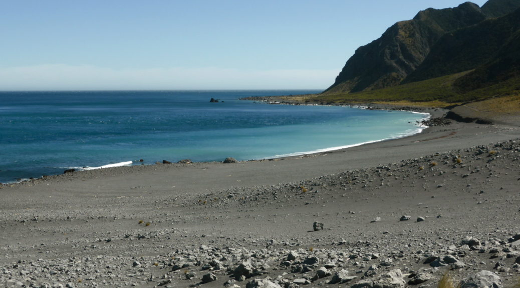
But it did lead to views such as this looking across Palliser Bay.

Open farmland took me closer to Cook Strait, and gave views of the South Island.

One last super steep bit to get down to the coastal road, which may involved an elegant running jump from the bike as I lost control on the sketchy gravel.

Refilling water bottles at DOC’s Te Kopi holiday cabins, it was time to take full advantage of the strong tail wind to push me down to the southern extremity of the route. Head down and legs getting meteorological assistance, I was soon at Ngawi ordering fresh fish and mussels from the little caravan-housed fish and chip shop. At the halfway point of the day’s route, I thought I was on track being three o’clock – I just had to get around the cape, through a sheep station and then it was road all the way back. Into the wind; I had not forgotten that part.

Blown all the way to Cape Palliser, I skipped climbing the big staircase in cleats – having done so on my previous ride here.

Soon after the lighthouse, the road ends and there’s just a track (behind a large gate that warns that there is no access to White Rock Road – I ignored this, knowing that there was access for bikes). Shingly and sandy the double track splits and rejoins in main places as it winds its way along the grass barely holding onto life on the windswept coast. The wind became much more difficult to predict as it hustled through the little valleys that run down to the coast; the blustery nature of it was no longer helpful.

The track became gravelly and rose a bit give a slightly higher vantage point.

I’d long since passed the last vehicle out for a spot of fishing or wild-camping and as afternoon drew to a close, the remoteness and isolation of the setting became more apparent. If I thought the hike-a-bike was over for the day, it definitely was not. The shingle got bigger and looser – not possible to ride through on a standard MTB tyre. I resorted to pushing up a relatively small hill. When it was a rideable surface again, there was another steep pitch that I got halfway up before dismounting yet again and walking to the top. The trail dropped off suddenly to an imposing high, heavy, locked steel gate – the boundary with Ngapotiki Station.

White Rock sitting across the bay. I turned north and inland at about that place.

While locked and difficult to get around, the gate bars legal access along a paper road through the station. I’d phoned two days prior and told the station owner I was coming through, he had no problems with this. I muscled my bike over the gate, slowly, and enjoyed a better surface across the farm for a brief time – before hitting an equally large gate on the other side of the station.

Back on gravel road, I was soon at the other end of White Rock Road – all I had to do was follow it for near on sixty kilometres back home. Being five o’clock there was plenty of daylight left, all I had to contend with were a few small hills. Oh, and a howling norwester headwind. Leaving the coast the road gradually climbed seventy-five metres. I struggled against the wind and chased a small bird up the road.

In a parallel with my toil, it would walk a few steps to get away from me and then attempt to fly. On each attempt the wind rushing down the hill would thwart it and send it back to the gravel. Finally it was close enough to the top of the rise and the wind lifted it and it flew gracefully away. I was not so graceful; near the top I came to a literal standstill in my easiest gear. As was becoming normal, I got off and walked again. On a gravel road! Believe it or not, I can actually ride a bike. A bit.

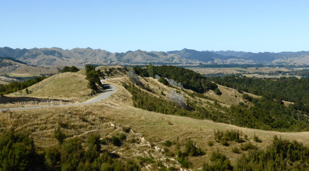
I was greeted with a view of an oddly braided river, the Opouawe, which I would follow upstream for sometime with little climbing. Occasionally I could even hide from the wind.

The gravel road riding was great, the wind not so.

Getting pretty low on energy from the day’s efforts, I stopped to eat my meagre dinner at six before two small climbs took me over to Tuturumuri. The school conveniently provided water refills and the road was paved from there.

I’d like to say progress now sped up, but it really did not. The wind was still fierce and the road climbed through three hundred metres, up to a wind farm – a ominous sign if there ever was one. Dealing with what was now a massive crosswind, I rode along the ridge and listened to the wind whistling. At first I thought the sound was the wind turbines, but I soon realised that the extraordinary noise was the wind rushing through the basic triple-wire power lines. Somehow my bike didn’t turn into a short-lived aircraft.

Finally the pay-off came as I, comparatively, whizzed down the hill to cross the Ruakokoputuna again, deal with a few undulations, turn my lights on and arrive back thirteen hours after departing. Those last sixty kilometres of road, with few hills took me four hours! It was a little breezy.

It was a fantastic day out exploring new places, but definitely a day with much hike-a-bike and toil. Three weeks later I’m wondering if I should try it again on a calmer day. Perhaps, but there are other places I’ve not been yet… Hindsight does of course tell me that my original plan to do this southern loop the previous day would have been much easier – but I got to spend more time with family, so all worth it.

No. 8 Wired – Northern Loop

Going south to visit family for a Waitangi Day extra-long weekend, coincided nicely with wanting to ride the bikepacking.com No. 8 Wired route. With a shortage on new NZ routes on the website, I’d been keen to ride this one since it was published last year as it would take me places I’d not been. As the name suggests, the route forms a figure eight. Conveniently, I was staying near the centre of the eight, so that gave good options to suit the weekend’s schedule.

I had planned to ride the southern, longer and more difficult, part of the route on Sunday before finishing with the easier northern loop the following day. But with extra family I’d not seen for a couple of years turning up, I switched that around to do the shorter day first.

After a long period of settled, hot weather the weekend started off cooler and gloomier than we were all used to. But Sunday dawned clear and still; as I only had about a hundred kilometres to ride, eight o’clock seemed a pretty civilised hour to depart.

Remembering the slightest part of the Tour Aotearoa route as I left town, I was soon climbing gradually and then not-so-gradually on quiet sealed roads to Hinakura.

A little gravel was nice to see rolling down the other side to the village (in the loosest possible sense).

Information overload after little but hills to look at since departing. Note made to ride out to the Pahaoa coast next time I’m down this way.

Didn’t stop here for long.

This chapel tacked on the end of the village hall was shut up tight.

The playground didn’t hold my attention for long; although I can report the slide still functions as such.

That’s better, just what I was looking for.

I was surprised by the sudden rush of traffic (four vehicles) around ten o’clock. Was this road busier than I expected? Nope, didn’t see another vehicle for hours. Quarter of an hour along the Pahaoa valley floor ended abruptly and the largest section of hills for the day started as the view opened up before and behind me.

Suddenly, a fertiliser dump. Somewhere around here…

Oh yes, there’s the air strip.

Lovely sunshine – however, it was still pleasantly mild, my sleeves didn’t come off all day.

A short descent down to the next valley floor, the Wainuioru, was soon replaced by the largest climb of the day. The views opened up again as I climbed to about five hundred metres; I enjoyed every twist in the road opening up a little more of the hilly views. Studying the map, there are still plenty more back roads to explore and discover more of the hills and coast nearby.

Before I knew it, that was basically the hill work for the day over – and it wasn’t even noon.

A fast descent to Gladstone ensued; the small village bringing back more Tour Aotearoa memories, before I turned off the TA route.

The route proper starts and finishes in Greytown, so I headed that way – realising I’ve never really been to the trendy little town, as I always take the faster route to Martinborough. It did nothing for me, so I rode through without even stopping for food (!) – so as to get back to see family. There were some nice, fast gravel options back to Martinborough mostly avoiding the busy road. However, if I wasn’t sticking to the route I’d have preferred the more interesting TA route down Longbush Road. I found I had energy to burn, so I did just that.

Home by two o’clock, most happy with an excellent day out in the hills in great riding weather seeing new places.

Te Apiti mud-fest (Waimarama, Kairakau S24O)

Waipukurau. Saturday. One o’clock.

That’s where Carl had to be to meet his family returning from Palmerston North. Why drive when you can ride a bike and camp at the beach overnight? A plan was hatched during the week to enable this and get some bikepacking, not to mention training for Tour Aotearoa for Carl, in. I managed to sort-of work in a paper road I’d wanted to ride for some time into the plan.

Friday after work there was much rushing to get my bike loaded before we rendezvoused at the mouth of the Tutaekuri River. Battling a strong on-shore wind, we met and the drizzle set in. Nearing six o’clock, would we have enough time to ride with loaded bikes the forty kilometres over the hills to Waimarama before the pub kitchen closed? (This is becoming a theme, one I quite like – ensuring one rides efficiently and fast enough to get one’s dinner. Strong motivation.)

Familiar cycle trails were easy miles as the rain strengthened. We crossed the Red Bridge and things became less familiar – I had been on this road once before, back in July. On a grey, damp evening traffic was light; there was ample opportunity to ride side-by-side and discuss bikepacking, TA details and thankfully, little work. With only three hundred metres of climbing, it was a leisurely Friday evening ride – the rain and the summer heat making it rather muggy. Ascending the last climb, the rain had ceased and it was pleasant riding as we drew closer to that kitchen.

At the crest of that climb, Waimarama Beach and Bare Island stretched in front of us.

Whizzing off the hill and along the flats, we made a bee-line for the pub, put our orders in and went to make camp at the local camping ground while the light held, as did the clouds. We returned to demolish our meals in one of those pubs where the patrons propping up the bar have not seen people riding into the local from a distant place, loaded with camping gear – it’s fun and amusing to be accorded astonishment and respect for such a small ride. Marveling at how achievable and great Friday-after-work bikepacking escapes are, we began plotting other possible ventures.

Rising after a sound sleep, decamping, and snacking we rolled off into a grey morning at the leisurely hour of seven o’clock. Gradually climbing up Te Apiti Road through farmland was an easy warm-up for the day. After ten kilometres we reached the end of the road and lifted our bikes over the gate onto Te Apiti Station. Checking in with the manager the day before, he’d warned Carl that it was raining and the track would be boggy. We figured we could deal with this.

It definitely wasn’t boggy. The track hardly looked wet. But we quickly found, when we couldn’t even ride up the first short, steep rise, that the innocent looking dirt track was exceptionally tacky. Rolling over it, walking over, the surface much preferred to detach itself from the earth and fasten itself to tyres and shoes. I have never experienced such vast quantities of such adhesive mud.

For two hours we tried to ride on the grass when possible; most often we couldn’t and so resorted to churning through the tackiness. This mostly consisted of pushing one’s bike until the wheels bound themselves in the frame, then dragging the bike and finally succumbing and stopping to remove vast wads of mud from, well, everything. At one stage in the middle of it all, we rode a few hundred metres and it was incredible! Just when it seemed to be getting better, we struck the worst patch yet – unfortunately this coincided with a steep, slippery ascent from which there was no escape to grass on the side. Getting ridiculous by then, we finally could look down and see a gravel farm track – it was almost over! That two hours got us a massive five and a half kilometres.

You know it’s bad when your 2.4″ tyres turn into 4″ fat tyres; and you know it has gotten worse when the mud has bridged over the rims.

My new shoes, bought to be more comfortable for hike-a-bike, were getting a bit of walking in – but not looking so new all of a sudden. On the bright side, I did grow a couple of inches in stature.

Usually I have plenty of clearance between tyre and fork – not this day.

Nope, that wheel is not turning.

The countryside was ruggedly beautiful, but mostly I remember the remarkable mud. Bliss to be on a gravel road, our speed increased as we crested a couple of smaller hills before rolling down to Kairakau Beach. A small settlement of holiday homes, we tried to find somewhere to clean our bikes and shed a few kilograms of mud. Once again attracting attention for being a little mad, two dear older couples from Napier with long (five or so generations) ties to the area plied us with a large pot of tea and biscuits. And let us use their hose to wash our bikes from brown back to black. Fantastic.

Carl had somewhere to be and I had to get home as I was expecting guests. It turns out that riding out of Kairakau involves a good 250 m climb at a decent seven percent gradient. A different type of work, but preferable to making little progress through the mud. We parted ways at Elsthorpe, I stopped in at a country equestrian meet expecting a food stall of some sort – I was not disappointed. I enjoyed my first ride along the undulating Kahuranaki Road and arrived home in plenty of time after battling the same on-shore wind.

A most excellent little outing, made more memorable by being a lot more challenging than expected. As I’m starting to say more often on little adventures that don’t go quite to plan – good training for something. What something will be remains to be seen.

Biking to go places, going places to bike.